Jambusar geodata
Jambusar (Gujarat) is a populated place; located in India in Asia/Kolkata (GMT+5.5) time zone. With population of 41,594 people, there are 1063 cities with bigger population in this country. Compared to other cities in India, 56.4% of cities are located further ↑North; 95.9% of cities are located further →East and 86% of cities have higher elevation than Jambusar. Note1


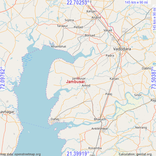
Jambusar GPS coordinates[2]
22° 3' 8.496" North, 72° 48' 2.664" East
| Map corner | latitude | longitude |
|---|---|---|
| Upper-left | 22.70253°, | 72.09762° |
| Center: | 22.05236°, | 72.80074° |
| Lower-right: | 21.39919°, | 73.50387° |
| Map W x H: | 144.9×144.9 km | = 90×90mi |
| max Lat: | 34.9274° ⇑56.4% North |
| Jambusar: | 22.05236° |
| min Lat: | ⇓43.6% South 8.09008° |
| min Long | Jambusar | max Long |
| 68.82655° | 72.80074° | 96.81° |
| W 4.1%⇐ | ⇒95.9% E |
Elevation
Elevation of Jambusar is 27 m = 89 ft, and this is 268.6 m = 881 ft below average elevation for this country.
| Max E: |
3681 m = 12077 ft | 86% |
| Avg. | 295.6 m = 970 ft | |
| Jambusar | 27 m = 89 ft | |
Min E: |
1 m = 3 ft | 14% |
See also: Jambusar elevation on elevation.city.
Geographical zone
Jambusar is located in North Torrid zone (between Equator and Tropic of Cancer). Distance of this Northern Tropic circle is 153.9 km =95.6 mi to North.| Distance of | km | miles | from Jambusar |
|---|---|---|---|
| North Pole | 7555.1 | 4694.5 | to North |
| Arctic Circle | 4949.2 | 3075.3 | to North |
| Tropic Cancer | 153.9 | 95.6 | to North |
| Equator | 2452 | 1523.6 | to South |


Nearby cities:
15 places around Jambusar: (largest is in red/bold)
• Amod
9.7 km =6 mi,  132°
132°
• Anand
57.8 km =35.9 mi,  15°
15°
• Ankleshwar
50.6 km =31.4 mi,  157°
157°
• Bharūch
43.9 km =27.3 mi,  154°
154°
• Borsad
40.8 km =25.4 mi,  14°
14°
• Dhuwaran
21.1 km =13.1 mi,  348°
348°
• Hansot
52 km =32.3 mi,  179°
179°
• Karamsad
55.5 km =34.5 mi, 11°
• Khambhāt
34.9 km =21.7 mi,  327°
327°
• Padra
35.9 km =22.3 mi,  54°
54°
• Petlād
47.2 km =29.3 mi,  359°
359°
• Sinor
57.7 km =35.9 mi,  105°
105°
• Sojītra
54.7 km =34 mi, 351°
• Vadodara
50.1 km =31.1 mi,  56°
56°
• Vallabh Vidyanagar
54.4 km =33.8 mi, 10°
Sources, notices
• [Note1] Compared only with cities in India existing in our database
• [Src1] Map data: © OpenStreetMap contributors (CC-BY-SA)
• [Src2] Other city data from geonames.org with taken over terms of usage.
• [Src3] Geographical zone / Annual Mean Temperature by Robert A. Rohde @ Wikipedia
