Amod geodata
Amod (Gujarat) is a populated place; located in India in Asia/Kolkata (GMT+5.5) time zone. With population of 18,742 people, there are 2148 cities with bigger population in this country. Compared to other cities in India, 56.7% of cities are located further ↑North; 95.6% of cities are located further →East and 91.1% of cities have higher elevation than Amod. Note1


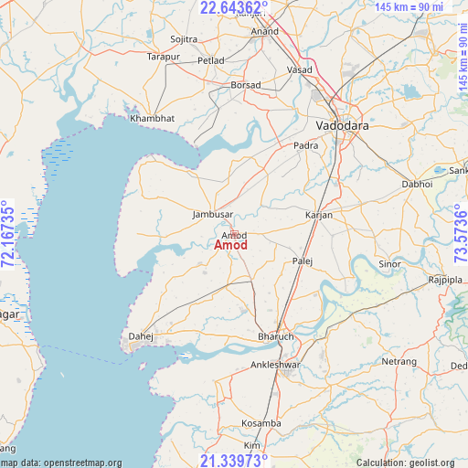
Amod GPS coordinates[2]
21° 59' 35.412" North, 72° 52' 13.692" East
| Map corner | latitude | longitude |
|---|---|---|
| Upper-left | 22.64362°, | 72.16735° |
| Center: | 21.99317°, | 72.87047° |
| Lower-right: | 21.33973°, | 73.5736° |
| Map W x H: | 145×145 km | = 90.1×90.1mi |
| max Lat: | 34.9274° ⇑56.7% North |
| Amod: | 21.99317° |
| min Lat: | ⇓43.3% South 8.09008° |
| min Long | Amod | max Long |
| 68.82655° | 72.87047° | 96.81° |
| W 4.4%⇐ | ⇒95.6% E |
Elevation
Elevation of Amod is 16 m = 52 ft, and this is 279.6 m = 917 ft below average elevation for this country.
| Max E: |
3681 m = 12077 ft | 91.1% |
| Avg. | 295.6 m = 970 ft | |
| Amod | 16 m = 52 ft | |
Min E: |
1 m = 3 ft | 8.9% |
See also: India elevation on elevation.city.
Geographical zone
Amod is located in North Torrid zone (between Equator and Tropic of Cancer). Distance of this Northern Tropic circle is 160.5 km =99.7 mi to North.| Distance of | km | miles | from Amod |
|---|---|---|---|
| North Pole | 7561.7 | 4698.6 | to North |
| Arctic Circle | 4955.8 | 3079.4 | to North |
| Tropic Cancer | 160.5 | 99.7 | to North |
| Equator | 2445.4 | 1519.5 | to South |


Nearby cities:
15 places around Amod: (largest is in red/bold)
• Ankleshwar
42 km =26.1 mi,  162°
162°
• Bharūch
35.1 km =21.8 mi, 161°
• Borsad
46.2 km =28.7 mi,  3°
3°
• Dabhoi
61.7 km =38.3 mi,  69°
69°
• Dhuwaran
29.5 km =18.3 mi,  337°
337°
• Hansot
45.8 km =28.5 mi,  188°
188°
• Jambusar
9.7 km =6 mi,  312°
312°
• Karamsad
61.2 km =38 mi, 3°
• Khambhāt
44.4 km =27.6 mi,  324°
324°
• Kosamba
59.8 km =37.2 mi,  171°
171°
• Padra
35.2 km =21.9 mi,  38°
38°
• Petlād
54.3 km =33.7 mi,  352°
352°
• Sinor
49.2 km =30.6 mi,  100°
100°
• Vadodara
48.7 km =30.3 mi,  45°
45°
• Vallabh Vidyanagar
60.1 km =37.3 mi, 2°
Sources, notices
• [Note1] Compared only with cities in India existing in our database
• [Src1] Map data: © OpenStreetMap contributors (CC-BY-SA)
• [Src2] Other city data from geonames.org with taken over terms of usage.
• [Src3] Geographical zone / Annual Mean Temperature by Robert A. Rohde @ Wikipedia
