Shillong geodata
Shillong (Meghalaya) is a seat of a first-order administrative division; located in India in Asia/Kolkata (GMT+5.5) time zone. With population of 132,842 people, there are 328 cities with bigger population in this country. Compared to other cities in India, 67.4% of cities are located further ↓South; 96.9% of cities are located further ←West and 97.7% of cities have lower elevation than Shillong. Note1


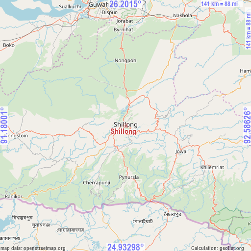
Shillong GPS coordinates[2]
25° 34' 8.112" North, 91° 52' 59.268" East
| Map corner | latitude | longitude |
|---|---|---|
| Upper-left | 26.2015°, | 91.18001° |
| Center: | 25.56892°, | 91.88313° |
| Lower-right: | 24.93298°, | 92.58626° |
| Map W x H: | 141×141 km | = 87.6×87.6mi |
| max Lat: | 34.9274° ⇑32.6% North |
| Shillong: | 25.56892° |
| min Lat: | ⇓67.4% South 8.09008° |
| min Long | Shillong | max Long |
| 68.82655° | 91.88313° | 96.81° |
| W 96.9%⇐ | ⇒3.1% E |
Elevation
Elevation of Shillong is 1507 m = 4944 ft, and this is 1211.4 m = 3974 ft above average elevation for this country.
| Max E: |
3681 m = 12077 ft | 2.3% |
| Shillong | 1507 m 4944 ft | |
| Avg. | 295.6 m = 970 ft | |
Min E: |
1 m = 3 ft | 97.7% |
See also: Shillong elevation on elevation.city.
Geographical zone
Shillong is located in North temperate zone (between Tropic of Cancer and the Arctic Circle). Distance of this Northern Tropic circle is 237.1 km =147.3 mi to South.| Distance of | km | miles | from Shillong |
|---|---|---|---|
| North Pole | 7164.1 | 4451.6 | to North |
| Arctic Circle | 4558.2 | 2832.3 | to North |
| Tropic Cancer | 237.1 | 147.3 | to South |
| Equator | 2843 | 1766.6 | to South |


Nearby cities:
15 places around Shillong: (largest is in red/bold)
• Cherrapunji
35.2 km =21.9 mi,  212°
212°
• Dispur
63.6 km =39.5 mi,  352°
352°
• Guwahati
69.8 km =43.4 mi, 348°
• Hamren
83.9 km =52.1 mi,  61°
61°
• Hājo
83.3 km =51.8 mi,  334°
334°
• Karīmganj
91.2 km =56.7 mi,  148°
148°
• Khliehriat
53.9 km =33.5 mi,  115°
115°
• Mairang
24.8 km =15.4 mi,  268°
268°
• Morigaon
88.8 km =55.2 mi,  31°
31°
• Nongpoh
37.1 km =23.1 mi,  359°
359°
• Nongstoin
62.3 km =38.7 mi,  264°
264°
• North Guwāhāti
71.8 km =44.6 mi, 346°
• Palāsbāri
70.6 km =43.9 mi, 330°
• Rahā
97.3 km =60.5 mi,  40°
40°
• Soalkuchi
73.6 km =45.7 mi, 334°
Sources, notices
• [Note1] Compared only with cities in India existing in our database
• [Src1] Map data: © OpenStreetMap contributors (CC-BY-SA)
• [Src2] Other city data from geonames.org with taken over terms of usage.
• [Src3] Geographical zone / Annual Mean Temperature by Robert A. Rohde @ Wikipedia
