Badvel geodata
Badvel (Andhra Pradesh) is a populated place; located in India in Asia/Kolkata (GMT+5.5) time zone. With population of 16,238 people, there are 2354 cities with bigger population in this country. Compared to other cities in India, 82% of cities are located further ↑North; 59.5% of cities are located further ←West and 61.8% of cities have higher elevation than Badvel. Note1


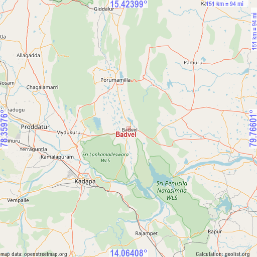
Badvel GPS coordinates[2]
14° 44' 42.36" North, 79° 3' 46.368" East
| Map corner | latitude | longitude |
|---|---|---|
| Upper-left | 15.42399°, | 78.35976° |
| Center: | 14.7451°, | 79.06288° |
| Lower-right: | 14.06408°, | 79.76601° |
| Map W x H: | 151.2×151.2 km | = 94×94mi |
| max Lat: | 34.9274° ⇑82% North |
| Badvel: | 14.7451° |
| min Lat: | ⇓18% South 8.09008° |
| min Long | Badvel | max Long |
| 68.82655° | 79.06288° | 96.81° |
| W 59.5%⇐ | ⇒40.5% E |
Elevation
Elevation of Badvel is 139 m = 456 ft, and this is 156.6 m = 514 ft below average elevation for this country.
| Max E: |
3681 m = 12077 ft | 61.8% |
| Avg. | 295.6 m = 970 ft | |
| Badvel | 139 m = 456 ft | |
Min E: |
1 m = 3 ft | 38.2% |
See also: India elevation on elevation.city.
Geographical zone
Badvel is located in North Torrid zone (between Equator and Tropic of Cancer). Distance of this Northern Tropic circle is 966.4 km =600.5 mi to North.| Distance of | km | miles | from Badvel |
|---|---|---|---|
| North Pole | 8367.6 | 5199.4 | to North |
| Arctic Circle | 5761.7 | 3580.2 | to North |
| Tropic Cancer | 966.4 | 600.5 | to North |
| Equator | 1639.5 | 1018.7 | to South |


Nearby cities:
15 places around Badvel: (largest is in red/bold)
• Chinnachowk
38.7 km =24 mi,  219°
219°
• Cuddapah
39.2 km =24.4 mi, 221°
• Cumbum
93.2 km =57.9 mi,  3°
3°
• Diguvametta
76.5 km =47.5 mi,  340°
340°
• Erraguntla
57.5 km =35.7 mi,  258°
258°
• Giddalūr
71.5 km =44.4 mi,  348°
348°
• Jammalamadugu
73.9 km =45.9 mi,  278°
278°
• Kanigiri
87.6 km =54.4 mi,  32°
32°
• Kāmalāpuram
45.4 km =28.2 mi,  248°
248°
• Nāgireddipalli
53 km =32.9 mi,  175°
175°
• Proddatūr
55.4 km =34.4 mi,  270°
270°
• Pulivendla
97.1 km =60.3 mi, 248°
• Rāyachoti
83.6 km =51.9 mi,  203°
203°
• Rāzampeta
62 km =38.5 mi,  170°
170°
• Vadlapūdi
93.3 km =58 mi,  121°
121°
Sources, notices
• [Note1] Compared only with cities in India existing in our database
• [Src1] Map data: © OpenStreetMap contributors (CC-BY-SA)
• [Src2] Other city data from geonames.org with taken over terms of usage.
• [Src3] Geographical zone / Annual Mean Temperature by Robert A. Rohde @ Wikipedia
