Singarāyakonda geodata
Singarāyakonda (Andhra Pradesh) is a populated place; located in India in Asia/Kolkata (GMT+5.5) time zone. With population of 17,796 people, there are 2217 cities with bigger population in this country. Compared to other cities in India, 81.1% of cities are located further ↑North; 68% of cities are located further ←West and 90.4% of cities have higher elevation than Singarāyakonda. Note1


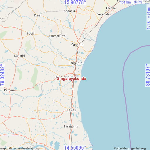
Singarāyakonda GPS coordinates[2]
15° 13' 49.656" North, 80° 1' 40.584" East
| Map corner | latitude | longitude |
|---|---|---|
| Upper-left | 15.90778°, | 79.32482° |
| Center: | 15.23046°, | 80.02794° |
| Lower-right: | 14.55095°, | 80.73107° |
| Map W x H: | 150.9×150.9 km | = 93.8×93.8mi |
| max Lat: | 34.9274° ⇑81.1% North |
| Singarāyakonda: | 15.23046° |
| min Lat: | ⇓18.9% South 8.09008° |
| min Long | Singarāyakonda | max Long |
| 68.82655° | 80.02794° | 96.81° |
| W 68%⇐ | ⇒32% E |
Elevation
Elevation of Singarāyakonda is 17 m = 56 ft, and this is 278.6 m = 914 ft below average elevation for this country.
| Max E: |
3681 m = 12077 ft | 90.4% |
| Avg. | 295.6 m = 970 ft | |
| Singarāyakonda | 17 m = 56 ft | |
Min E: |
1 m = 3 ft | 9.6% |
See also: India elevation on elevation.city.
Geographical zone
Singarāyakonda is located in North Torrid zone (between Equator and Tropic of Cancer). Distance of this Northern Tropic circle is 912.5 km =567 mi to North.| Distance of | km | miles | from Singarāyakonda |
|---|---|---|---|
| North Pole | 8313.6 | 5165.8 | to North |
| Arctic Circle | 5707.7 | 3546.6 | to North |
| Tropic Cancer | 912.5 | 567 | to North |
| Equator | 1693.5 | 1052.3 | to South |


Nearby cities:
15 places around Singarāyakonda: (largest is in red/bold)
• Addanki
64.8 km =40.3 mi,  354°
354°
• Bāpatla
88.5 km =55 mi,  32°
32°
• Chilakalūrupet
96.7 km =60.1 mi,  8°
8°
• Chīrāla
74.6 km =46.4 mi, 27°
• Darsi
70.6 km =43.9 mi,  328°
328°
• Kandukūr
13.4 km =8.3 mi,  262°
262°
• Kanigiri
59.2 km =36.8 mi,  289°
289°
• Kovūr
81.3 km =50.5 mi,  183°
183°
• Kāvali
35.1 km =21.8 mi,  185°
185°
• Nellore
86.9 km =54 mi, 182°
• Ongole
30.4 km =18.9 mi,  3°
3°
• Pavuluru
70.7 km =43.9 mi, 11°
• Vetapālem
68.5 km =42.6 mi, 25°
• Vinukonda
96.5 km =60 mi,  341°
341°
• pedda nakkalapalem
72.2 km =44.9 mi, 11°
Sources, notices
• [Note1] Compared only with cities in India existing in our database
• [Src1] Map data: © OpenStreetMap contributors (CC-BY-SA)
• [Src2] Other city data from geonames.org with taken over terms of usage.
• [Src3] Geographical zone / Annual Mean Temperature by Robert A. Rohde @ Wikipedia
