Kāvali geodata
Kāvali (Andhra Pradesh) is a populated place; located in India in Asia/Kolkata (GMT+5.5) time zone. With population of 83,352 people, there are 530 cities with bigger population in this country. Compared to other cities in India, 81.7% of cities are located further ↑North; 67.7% of cities are located further ←West and 89.9% of cities have higher elevation than Kāvali. Note1


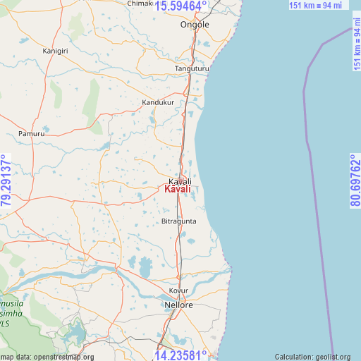
Kāvali GPS coordinates[2]
14° 54' 58.68" North, 79° 59' 40.164" East
| Map corner | latitude | longitude |
|---|---|---|
| Upper-left | 15.59464°, | 79.29137° |
| Center: | 14.9163°, | 79.99449° |
| Lower-right: | 14.23581°, | 80.69762° |
| Map W x H: | 151.1×151.1 km | = 93.9×93.9mi |
| max Lat: | 34.9274° ⇑81.7% North |
| Kāvali: | 14.9163° |
| min Lat: | ⇓18.3% South 8.09008° |
| min Long | Kāvali | max Long |
| 68.82655° | 79.99449° | 96.81° |
| W 67.7%⇐ | ⇒32.3% E |
Elevation
Elevation of Kāvali is 18 m = 59 ft, and this is 277.6 m = 911 ft below average elevation for this country.
| Max E: |
3681 m = 12077 ft | 89.9% |
| Avg. | 295.6 m = 970 ft | |
| Kāvali | 18 m = 59 ft | |
Min E: |
1 m = 3 ft | 10.1% |
See also: Kāvali elevation on elevation.city.
Geographical zone
Kāvali is located in North Torrid zone (between Equator and Tropic of Cancer). Distance of this Northern Tropic circle is 947.4 km =588.7 mi to North.| Distance of | km | miles | from Kāvali |
|---|---|---|---|
| North Pole | 8348.5 | 5187.5 | to North |
| Arctic Circle | 5742.6 | 3568.3 | to North |
| Tropic Cancer | 947.4 | 588.7 | to North |
| Equator | 1658.5 | 1030.5 | to South |


Nearby cities:
15 places around Kāvali: (largest is in red/bold)
• Addanki
99.5 km =61.8 mi,  358°
358°
• Badvel
101.9 km =63.3 mi,  259°
259°
• Chīrāla
108 km =67.1 mi,  20°
20°
• Darsi
100.7 km =62.6 mi,  340°
340°
• Gūdūr
86.5 km =53.7 mi,  190°
190°
• Kandukūr
34.7 km =21.6 mi, 343°
• Kanigiri
75.5 km =46.9 mi,  316°
316°
• Kovūr
46.2 km =28.7 mi,  181°
181°
• Nellore
51.9 km =32.2 mi, 180°
• Ongole
65.5 km =40.7 mi,  4°
4°
• Pavuluru
105.7 km =65.7 mi,  9°
9°
• Singarāyakonda
35.1 km =21.8 mi, 5°
• Vadlapūdi
70.3 km =43.7 mi,  196°
196°
• Vetapālem
102.2 km =63.5 mi, 19°
• pedda nakkalapalem
107.2 km =66.6 mi, 9°
Sources, notices
• [Note1] Compared only with cities in India existing in our database
• [Src1] Map data: © OpenStreetMap contributors (CC-BY-SA)
• [Src2] Other city data from geonames.org with taken over terms of usage.
• [Src3] Geographical zone / Annual Mean Temperature by Robert A. Rohde @ Wikipedia
