Bāpatla geodata
Bāpatla (Andhra Pradesh) is a populated place; located in India in Asia/Kolkata (GMT+5.5) time zone. With population of 70,117 people, there are 620 cities with bigger population in this country. Compared to other cities in India, 78.2% of cities are located further ↑North; 70.8% of cities are located further ←West and 96.4% of cities have higher elevation than Bāpatla. Note1


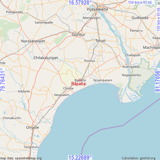
Bāpatla GPS coordinates[2]
15° 54' 15.192" North, 80° 28' 2.748" East
| Map corner | latitude | longitude |
|---|---|---|
| Upper-left | 16.57928°, | 79.76431° |
| Center: | 15.90422°, | 80.46743° |
| Lower-right: | 15.22689°, | 81.17056° |
| Map W x H: | 150.4×150.4 km | = 93.5×93.5mi |
| max Lat: | 34.9274° ⇑78.2% North |
| Bāpatla: | 15.90422° |
| min Lat: | ⇓21.8% South 8.09008° |
| min Long | Bāpatla | max Long |
| 68.82655° | 80.46743° | 96.81° |
| W 70.8%⇐ | ⇒29.2% E |
Elevation
Elevation of Bāpatla is 10 m = 33 ft, and this is 285.6 m = 937 ft below average elevation for this country.
| Max E: |
3681 m = 12077 ft | 96.4% |
| Avg. | 295.6 m = 970 ft | |
| Bāpatla | 10 m = 33 ft | |
Min E: |
1 m = 3 ft | 3.6% |
See also: Bāpatla elevation on elevation.city.
Geographical zone
Bāpatla is located in North Torrid zone (between Equator and Tropic of Cancer). Distance of this Northern Tropic circle is 837.5 km =520.4 mi to North.| Distance of | km | miles | from Bāpatla |
|---|---|---|---|
| North Pole | 8238.7 | 5119.3 | to North |
| Arctic Circle | 5632.8 | 3500.1 | to North |
| Tropic Cancer | 837.5 | 520.4 | to North |
| Equator | 1768.4 | 1098.8 | to South |


Nearby cities:
15 places around Bāpatla: (largest is in red/bold)
• Addanki
53.9 km =33.5 mi,  258°
258°
• Avanigadda
49.9 km =31 mi,  74°
74°
• Bhattiprolu
40.1 km =24.9 mi,  56°
56°
• Challapalle
55 km =34.2 mi, 64°
• Chilakalūrupet
38.2 km =23.7 mi,  302°
302°
• Chīrāla
15.2 km =9.4 mi,  234°
234°
• Govindapuram,Chilakaluripet,Guntur
47.9 km =29.8 mi,  305°
305°
• Guntur
44 km =27.3 mi,  358°
358°
• Pavuluru
32.9 km =20.4 mi, 260°
• Phirangipuram
48.2 km =30 mi,  332°
332°
• Ponnur
20.5 km =12.7 mi,  25°
25°
• Ponnūru
20.1 km =12.5 mi, 26°
• Repalle
40.7 km =25.3 mi, 71°
• Vetapālem
21.7 km =13.5 mi, 232°
• pedda nakkalapalem
32.9 km =20.4 mi, 262°
Sources, notices
• [Note1] Compared only with cities in India existing in our database
• [Src1] Map data: © OpenStreetMap contributors (CC-BY-SA)
• [Src2] Other city data from geonames.org with taken over terms of usage.
• [Src3] Geographical zone / Annual Mean Temperature by Robert A. Rohde @ Wikipedia
