Chīrāla geodata
Chīrāla (Andhra Pradesh) is a populated place; located in India in Asia/Kolkata (GMT+5.5) time zone. With population of 87,001 people, there are 512 cities with bigger population in this country. Compared to other cities in India, 78.5% of cities are located further ↑North; 70.6% of cities are located further ←West and 95.4% of cities have higher elevation than Chīrāla. Note1


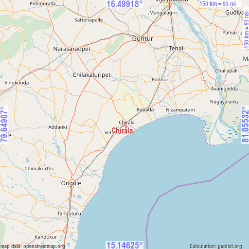
Chīrāla GPS coordinates[2]
15° 49' 25.86" North, 80° 21' 7.884" East
| Map corner | latitude | longitude |
|---|---|---|
| Upper-left | 16.49918°, | 79.64907° |
| Center: | 15.82385°, | 80.35219° |
| Lower-right: | 15.14625°, | 81.05532° |
| Map W x H: | 150.4×150.4 km | = 93.5×93.5mi |
| max Lat: | 34.9274° ⇑78.5% North |
| Chīrāla: | 15.82385° |
| min Lat: | ⇓21.5% South 8.09008° |
| min Long | Chīrāla | max Long |
| 68.82655° | 80.35219° | 96.81° |
| W 70.6%⇐ | ⇒29.4% E |
Elevation
Elevation of Chīrāla is 11 m = 36 ft, and this is 284.6 m = 934 ft below average elevation for this country.
| Max E: |
3681 m = 12077 ft | 95.4% |
| Avg. | 295.6 m = 970 ft | |
| Chīrāla | 11 m = 36 ft | |
Min E: |
1 m = 3 ft | 4.6% |
See also: Chīrāla elevation on elevation.city.
Geographical zone
Chīrāla is located in North Torrid zone (between Equator and Tropic of Cancer). Distance of this Northern Tropic circle is 846.5 km =526 mi to North.| Distance of | km | miles | from Chīrāla |
|---|---|---|---|
| North Pole | 8247.6 | 5124.8 | to North |
| Arctic Circle | 5641.7 | 3505.6 | to North |
| Tropic Cancer | 846.5 | 526 | to North |
| Equator | 1759.4 | 1093.2 | to South |


Nearby cities:
15 places around Chīrāla: (largest is in red/bold)
• Addanki
40.6 km =25.2 mi,  267°
267°
• Bhattiprolu
55.3 km =34.4 mi,  55°
55°
• Bāpatla
15.2 km =9.4 mi,  54°
54°
• Chilakalūrupet
35.6 km =22.1 mi,  326°
326°
• Govindapuram,Chilakaluripet,Guntur
45.4 km =28.2 mi,  324°
324°
• Guntur
54.1 km =33.6 mi,  11°
11°
• Narasaraopet
56 km =34.8 mi, 324°
• Ongole
48.5 km =30.1 mi,  222°
222°
• Pavuluru
20.3 km =12.6 mi,  279°
279°
• Phirangipuram
52.8 km =32.8 mi,  349°
349°
• Ponnur
34.7 km =21.6 mi,  37°
37°
• Ponnūru
34.3 km =21.3 mi, 38°
• Repalle
55.4 km =34.4 mi,  67°
67°
• Vetapālem
6.5 km =4 mi,  228°
228°
• pedda nakkalapalem
20.9 km =13 mi, 283°
Sources, notices
• [Note1] Compared only with cities in India existing in our database
• [Src1] Map data: © OpenStreetMap contributors (CC-BY-SA)
• [Src2] Other city data from geonames.org with taken over terms of usage.
• [Src3] Geographical zone / Annual Mean Temperature by Robert A. Rohde @ Wikipedia
