Khammam geodata
Khammam (Telangana) is a populated place; located in India in Asia/Kolkata (GMT+5.5) time zone. With population of 170,503 people, there are 253 cities with bigger population in this country. Compared to other cities in India, 74.2% of cities are located further ↑North; 68.9% of cities are located further ←West and 65% of cities have higher elevation than Khammam. Note1


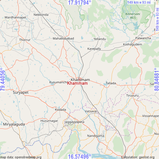
Khammam GPS coordinates[2]
17° 14' 51.612" North, 80° 8' 37.248" East
| Map corner | latitude | longitude |
|---|---|---|
| Upper-left | 17.91794°, | 79.44056° |
| Center: | 17.24767°, | 80.14368° |
| Lower-right: | 16.57496°, | 80.84681° |
| Map W x H: | 149.3×149.3 km | = 92.8×92.8mi |
| max Lat: | 34.9274° ⇑74.2% North |
| Khammam: | 17.24767° |
| min Lat: | ⇓25.8% South 8.09008° |
| min Long | Khammam | max Long |
| 68.82655° | 80.14368° | 96.81° |
| W 68.9%⇐ | ⇒31.1% E |
Elevation
Elevation of Khammam is 120 m = 394 ft, and this is 175.6 m = 576 ft below average elevation for this country.
| Max E: |
3681 m = 12077 ft | 65% |
| Avg. | 295.6 m = 970 ft | |
| Khammam | 120 m = 394 ft | |
Min E: |
1 m = 3 ft | 35% |
See also: Khammam elevation on elevation.city.
Geographical zone
Khammam is located in North Torrid zone (between Equator and Tropic of Cancer). Distance of this Northern Tropic circle is 688.2 km =427.6 mi to North.| Distance of | km | miles | from Khammam |
|---|---|---|---|
| North Pole | 8089.3 | 5026.5 | to North |
| Arctic Circle | 5483.4 | 3407.2 | to North |
| Tropic Cancer | 688.2 | 427.6 | to North |
| Equator | 1917.8 | 1191.7 | to South |


Nearby cities:
15 places around Khammam: (largest is in red/bold)
• Chātakonda
63.3 km =39.3 mi,  57°
57°
• Dornakal
21.9 km =13.6 mi,  1°
1°
• Jaggayyapeta
39.6 km =24.6 mi,  187°
187°
• Kodār
33.6 km =20.9 mi,  214°
214°
• Kondapalle
81.7 km =50.8 mi,  148°
148°
• Kottagūdem
60.6 km =37.7 mi, 56°
• Mahbūbābād
41.7 km =25.9 mi,  338°
338°
• Miriālgūda
74.6 km =46.4 mi,  235°
235°
• Nandigāma
55 km =34.2 mi,  164°
164°
• Nūzvīd
90.4 km =56.2 mi,  124°
124°
• Palwancha
67.6 km =42 mi, 56°
• Pāloncha
71.4 km =44.4 mi, 56°
• Sathupalli
77 km =47.8 mi,  89°
89°
• Suriāpet
56.8 km =35.3 mi,  257°
257°
• Yellandu
42.5 km =26.4 mi,  26°
26°
Sources, notices
• [Note1] Compared only with cities in India existing in our database
• [Src1] Map data: © OpenStreetMap contributors (CC-BY-SA)
• [Src2] Other city data from geonames.org with taken over terms of usage.
• [Src3] Geographical zone / Annual Mean Temperature by Robert A. Rohde @ Wikipedia
