Kodār geodata
Kodār (Telangana) is a populated place; located in India in Asia/Kolkata (GMT+5.5) time zone. With population of 59,170 people, there are 742 cities with bigger population in this country. Compared to other cities in India, 74.8% of cities are located further ↑North; 67.5% of cities are located further ←West and 66% of cities have higher elevation than Kodār. Note1


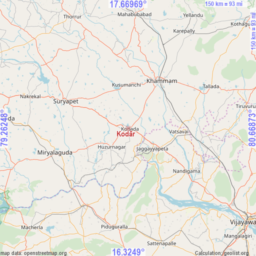
Kodār GPS coordinates[2]
16° 59' 54.6" North, 79° 57' 56.16" East
| Map corner | latitude | longitude |
|---|---|---|
| Upper-left | 17.66969°, | 79.26248° |
| Center: | 16.9985°, | 79.9656° |
| Lower-right: | 16.3249°, | 80.66873° |
| Map W x H: | 149.5×149.5 km | = 92.9×92.9mi |
| max Lat: | 34.9274° ⇑74.8% North |
| Kodār: | 16.9985° |
| min Lat: | ⇓25.2% South 8.09008° |
| min Long | Kodār | max Long |
| 68.82655° | 79.9656° | 96.81° |
| W 67.5%⇐ | ⇒32.5% E |
Elevation
Elevation of Kodār is 113 m = 371 ft, and this is 182.6 m = 599 ft below average elevation for this country.
| Max E: |
3681 m = 12077 ft | 66% |
| Avg. | 295.6 m = 970 ft | |
| Kodār | 113 m = 371 ft | |
Min E: |
1 m = 3 ft | 34% |
See also: Kodār elevation on elevation.city.
Geographical zone
Kodār is located in North Torrid zone (between Equator and Tropic of Cancer). Distance of this Northern Tropic circle is 715.9 km =444.8 mi to North.| Distance of | km | miles | from Kodār |
|---|---|---|---|
| North Pole | 8117 | 5043.7 | to North |
| Arctic Circle | 5511.1 | 3424.4 | to North |
| Tropic Cancer | 715.9 | 444.8 | to North |
| Equator | 1890.1 | 1174.5 | to South |


Nearby cities:
15 places around Kodār: (largest is in red/bold)
• Dornakal
53.3 km =33.1 mi,  21°
21°
• Jaggayyapeta
18.3 km =11.4 mi,  129°
129°
• Khammam
33.6 km =20.9 mi,  34°
34°
• Kondapalle
74.4 km =46.2 mi,  124°
124°
• Mahbūbābād
66.7 km =41.4 mi,  3°
3°
• Miriālgūda
45.1 km =28 mi,  251°
251°
• Mācherla
81 km =50.3 mi,  224°
224°
• Nalgonda
74.5 km =46.3 mi,  274°
274°
• Nandigāma
42.4 km =26.3 mi, 126°
• Narasaraopet
85.4 km =53.1 mi,  174°
174°
• Phirangipuram
84.8 km =52.7 mi,  158°
158°
• Sattenapalle
70.1 km =43.6 mi, 163°
• Suriāpet
39.9 km =24.8 mi,  293°
293°
• Tādepalle
88.6 km =55.1 mi, 130°
• Yellandu
75.9 km =47.2 mi, 29°
Sources, notices
• [Note1] Compared only with cities in India existing in our database
• [Src1] Map data: © OpenStreetMap contributors (CC-BY-SA)
• [Src2] Other city data from geonames.org with taken over terms of usage.
• [Src3] Geographical zone / Annual Mean Temperature by Robert A. Rohde @ Wikipedia
