Namli geodata
Namli (Madhya Pradesh) is a populated place; located in India in Asia/Kolkata (GMT+5.5) time zone. With population of 9,235 people, there are 3018 cities with bigger population in this country. Compared to other cities in India, 54.6% of cities are located further ↓South; 82.2% of cities are located further →East and 82.1% of cities have lower elevation than Namli. Note1


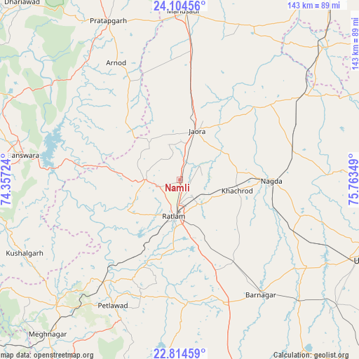
Namli GPS coordinates[2]
23° 27' 40.14" North, 75° 3' 37.296" East
| Map corner | latitude | longitude |
|---|---|---|
| Upper-left | 24.10456°, | 74.35724° |
| Center: | 23.46115°, | 75.06036° |
| Lower-right: | 22.81459°, | 75.76349° |
| Map W x H: | 143.4×143.4 km | = 89.1×89.1mi |
| max Lat: | 34.9274° ⇑45.4% North |
| Namli: | 23.46115° |
| min Lat: | ⇓54.6% South 8.09008° |
| min Long | Namli | max Long |
| 68.82655° | 75.06036° | 96.81° |
| W 17.8%⇐ | ⇒82.2% E |
Elevation
Elevation of Namli is 494 m = 1621 ft, and this is 198.4 m = 651 ft above average elevation for this country.
| Max E: |
3681 m = 12077 ft | 17.9% |
| Namli | 494 m 1621 ft | |
| Avg. | 295.6 m = 970 ft | |
Min E: |
1 m = 3 ft | 82.1% |
See also: India elevation on elevation.city.
Geographical zone
Namli is located in North temperate zone (between Tropic of Cancer and the Arctic Circle). Distance of this Northern Tropic circle is 2.7 km =1.7 mi to South.| Distance of | km | miles | from Namli |
|---|---|---|---|
| North Pole | 7398.4 | 4597.2 | to North |
| Arctic Circle | 4792.5 | 2977.9 | to North |
| Tropic Cancer | 2.7 | 1.7 | to South |
| Equator | 2608.6 | 1620.9 | to South |


Nearby cities:
15 places around Namli: (largest is in red/bold)
• Alot
60.7 km =37.7 mi,  56°
56°
• Badnāwar
51.9 km =32.2 mi,  160°
160°
• Bamna
50.9 km =31.6 mi,  216°
216°
• Bānswāra
63.6 km =39.5 mi,  278°
278°
• Gogāpur
47.7 km =29.6 mi,  77°
77°
• Jaorā
20.8 km =12.9 mi,  19°
19°
• Khāchrod
23 km =14.3 mi,  100°
100°
• Mandsaur
67.9 km =42.2 mi,  0°
0°
• Nagda
36.4 km =22.6 mi,  90°
90°
• Petlāwad
56.8 km =35.3 mi,  208°
208°
• Piploda
40 km =24.9 mi,  107°
107°
• Ratlām
14.7 km =9.1 mi,  188°
188°
• Sailāna
14 km =8.7 mi,  270°
270°
• Tāl
43.8 km =27.2 mi,  49°
49°
• Unhel
52.7 km =32.7 mi, 105°
Sources, notices
• [Note1] Compared only with cities in India existing in our database
• [Src1] Map data: © OpenStreetMap contributors (CC-BY-SA)
• [Src2] Other city data from geonames.org with taken over terms of usage.
• [Src3] Geographical zone / Annual Mean Temperature by Robert A. Rohde @ Wikipedia
