Bamna geodata
Bamna (Madhya Pradesh) is a populated place; located in India in Asia/Kolkata (GMT+5.5) time zone. With population of 9,034 people, there are 3030 cities with bigger population in this country. Compared to other cities in India, 52.3% of cities are located further ↓South; 84.8% of cities are located further →East and 75.7% of cities have lower elevation than Bamna. Note1


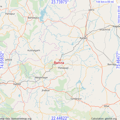
Bamna GPS coordinates[2]
23° 5' 40.344" North, 74° 45' 41.904" East
| Map corner | latitude | longitude |
|---|---|---|
| Upper-left | 23.73975°, | 74.05852° |
| Center: | 23.09454°, | 74.76164° |
| Lower-right: | 22.44622°, | 75.46477° |
| Map W x H: | 143.8×143.8 km | = 89.4×89.4mi |
| max Lat: | 34.9274° ⇑47.7% North |
| Bamna: | 23.09454° |
| min Lat: | ⇓52.3% South 8.09008° |
| min Long | Bamna | max Long |
| 68.82655° | 74.76164° | 96.81° |
| W 15.2%⇐ | ⇒84.8% E |
Elevation
Elevation of Bamna is 395 m = 1296 ft, and this is 99.4 m = 326 ft above average elevation for this country.
| Max E: |
3681 m = 12077 ft | 24.3% |
| Bamna | 395 m 1296 ft | |
| Avg. | 295.6 m = 970 ft | |
Min E: |
1 m = 3 ft | 75.7% |
See also: India elevation on elevation.city.
Geographical zone
Bamna is located in North Torrid zone (between Equator and Tropic of Cancer). Distance of this Northern Tropic circle is 38 km =23.6 mi to North.| Distance of | km | miles | from Bamna |
|---|---|---|---|
| North Pole | 7439.2 | 4622.5 | to North |
| Arctic Circle | 4833.3 | 3003.3 | to North |
| Tropic Cancer | 38 | 23.6 | to North |
| Equator | 2567.9 | 1595.6 | to South |


Nearby cities:
15 places around Bamna: (largest is in red/bold)
• Badnāwar
48.9 km =30.4 mi,  99°
99°
• Bānswāra
59.4 km =36.9 mi,  326°
326°
• Dohad
59 km =36.7 mi,  240°
240°
• Jaorā
71 km =44.1 mi,  31°
31°
• Jhābua
40.3 km =25 mi,  205°
205°
• Khāchrod
64.5 km =40.1 mi,  55°
55°
• Kushālgarh
33.8 km =21 mi,  290°
290°
• Namli
50.9 km =31.6 mi,  36°
36°
• Petlāwad
10 km =6.2 mi,  158°
158°
• Piploda
74.3 km =46.2 mi,  67°
67°
• Ratlām
38.7 km =24 mi,  47°
47°
• Rājgarh
50 km =31.1 mi, 157°
• Rānāpur
55.5 km =34.5 mi, 206°
• Sailāna
44.1 km =27.4 mi,  21°
21°
• Thandla
21.1 km =13.1 mi, 243°
Sources, notices
• [Note1] Compared only with cities in India existing in our database
• [Src1] Map data: © OpenStreetMap contributors (CC-BY-SA)
• [Src2] Other city data from geonames.org with taken over terms of usage.
• [Src3] Geographical zone / Annual Mean Temperature by Robert A. Rohde @ Wikipedia
