Alot geodata
Alot (Madhya Pradesh) is a populated place; located in India in Asia/Kolkata (GMT+5.5) time zone. With population of 23,134 people, there are 1826 cities with bigger population in this country. Compared to other cities in India, 56.5% of cities are located further ↓South; 78.1% of cities are located further →East and 79.3% of cities have lower elevation than Alot. Note1


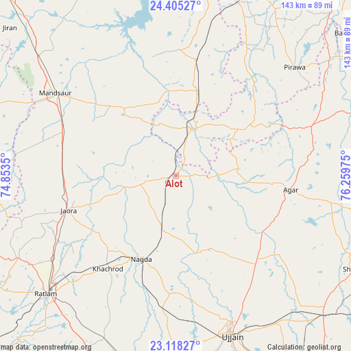
Alot GPS coordinates[2]
23° 45' 48.096" North, 75° 33' 23.832" East
| Map corner | latitude | longitude |
|---|---|---|
| Upper-left | 24.40527°, | 74.8535° |
| Center: | 23.76336°, | 75.55662° |
| Lower-right: | 23.11827°, | 76.25975° |
| Map W x H: | 143.1×143.1 km | = 88.9×88.9mi |
| max Lat: | 34.9274° ⇑43.5% North |
| Alot: | 23.76336° |
| min Lat: | ⇓56.5% South 8.09008° |
| min Long | Alot | max Long |
| 68.82655° | 75.55662° | 96.81° |
| W 21.9%⇐ | ⇒78.1% E |
Elevation
Elevation of Alot is 448 m = 1470 ft, and this is 152.4 m = 500 ft above average elevation for this country.
| Max E: |
3681 m = 12077 ft | 20.7% |
| Alot | 448 m 1470 ft | |
| Avg. | 295.6 m = 970 ft | |
Min E: |
1 m = 3 ft | 79.3% |
See also: India elevation on elevation.city.
Geographical zone
Alot is located in North temperate zone (between Tropic of Cancer and the Arctic Circle). Distance of this Northern Tropic circle is 36.3 km =22.6 mi to South.| Distance of | km | miles | from Alot |
|---|---|---|---|
| North Pole | 7364.8 | 4576.3 | to North |
| Arctic Circle | 4758.9 | 2957 | to North |
| Tropic Cancer | 36.3 | 22.6 | to South |
| Equator | 2642.2 | 1641.8 | to South |


Nearby cities:
15 places around Alot: (largest is in red/bold)
• Agar
47.1 km =29.3 mi,  96°
96°
• Gogāpur
23.3 km =14.5 mi,  190°
190°
• Jaorā
45.9 km =28.5 mi,  252°
252°
• Khāchrod
47.1 km =29.3 mi,  216°
216°
• Mandsaur
60.2 km =37.4 mi,  304°
304°
• Nagda
36.8 km =22.9 mi,  202°
202°
• Namli
60.7 km =37.7 mi,  236°
236°
• Piploda
47.6 km =29.6 mi, 195°
• Pirāwa
64.7 km =40.2 mi,  47°
47°
• Shāmgarh
48 km =29.8 mi,  10°
10°
• Susner
57.8 km =35.9 mi,  69°
69°
• Sītāmau
34.8 km =21.6 mi,  323°
323°
• Tāl
18.1 km =11.2 mi, 254°
• Ujjain
68.4 km =42.5 mi,  160°
160°
• Unhel
47.3 km =29.4 mi,  179°
179°
Sources, notices
• [Note1] Compared only with cities in India existing in our database
• [Src1] Map data: © OpenStreetMap contributors (CC-BY-SA)
• [Src2] Other city data from geonames.org with taken over terms of usage.
• [Src3] Geographical zone / Annual Mean Temperature by Robert A. Rohde @ Wikipedia
