Piploda geodata
Piploda (Madhya Pradesh) is a populated place; located in India in Asia/Kolkata (GMT+5.5) time zone. With population of 7,719 people, there are 3148 cities with bigger population in this country. Compared to other cities in India, 54% of cities are located further ↓South; 79% of cities are located further →East and 80.7% of cities have lower elevation than Piploda. Note1


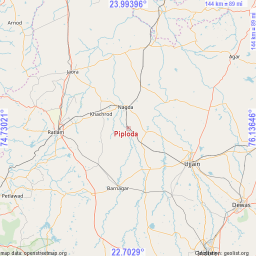
Piploda GPS coordinates[2]
23° 21' 0" North, 75° 25' 59.988" East
| Map corner | latitude | longitude |
|---|---|---|
| Upper-left | 23.99396°, | 74.73021° |
| Center: | 23.35°, | 75.43333° |
| Lower-right: | 22.7029°, | 76.13646° |
| Map W x H: | 143.6×143.6 km | = 89.2×89.2mi |
| max Lat: | 34.9274° ⇑46% North |
| Piploda: | 23.35° |
| min Lat: | ⇓54% South 8.09008° |
| min Long | Piploda | max Long |
| 68.82655° | 75.43333° | 96.81° |
| W 21%⇐ | ⇒79% E |
Elevation
Elevation of Piploda is 469 m = 1539 ft, and this is 173.4 m = 569 ft above average elevation for this country.
| Max E: |
3681 m = 12077 ft | 19.3% |
| Piploda | 469 m 1539 ft | |
| Avg. | 295.6 m = 970 ft | |
Min E: |
1 m = 3 ft | 80.7% |
See also: India elevation on elevation.city.
Geographical zone
Piploda is located in North Torrid zone (between Equator and Tropic of Cancer). Distance of this Northern Tropic circle is 9.6 km =6 mi to North.| Distance of | km | miles | from Piploda |
|---|---|---|---|
| North Pole | 7410.8 | 4604.9 | to North |
| Arctic Circle | 4804.9 | 2985.6 | to North |
| Tropic Cancer | 9.6 | 6 | to North |
| Equator | 2596.3 | 1613.3 | to South |


Nearby cities:
15 places around Piploda: (largest is in red/bold)
• Alot
47.6 km =29.6 mi,  15°
15°
• Badnāwar
41.9 km =26 mi,  209°
209°
• Depālpur
56.6 km =35.2 mi,  168°
168°
• Gautampura
41.3 km =25.7 mi, 167°
• Gogāpur
24.6 km =15.3 mi, 20°
• Jaorā
44.7 km =27.8 mi,  315°
315°
• Khāchrod
17.5 km =10.9 mi,  297°
297°
• Nagda
12.2 km =7.6 mi,  352°
352°
• Namli
40 km =24.9 mi,  287°
287°
• Ratlām
40.2 km =25 mi,  266°
266°
• Sailāna
53.5 km =33.2 mi,  283°
283°
• Sānwer
58 km =36 mi,  136°
136°
• Tāl
41.4 km =25.7 mi, 353°
• Ujjain
39.7 km =24.7 mi,  118°
118°
• Unhel
12.9 km =8 mi,  95°
95°
Sources, notices
• [Note1] Compared only with cities in India existing in our database
• [Src1] Map data: © OpenStreetMap contributors (CC-BY-SA)
• [Src2] Other city data from geonames.org with taken over terms of usage.
• [Src3] Geographical zone / Annual Mean Temperature by Robert A. Rohde @ Wikipedia
