Nagar geodata
Nagar (Himachal Pradesh) is a populated place; located in India in Asia/Kolkata (GMT+5.5) time zone. With population of 2,000 people, there are 3431 cities with bigger population in this country. Compared to other cities in India, 98.1% of cities are located further ↓South; 61.3% of cities are located further →East and 98.7% of cities have lower elevation than Nagar. Note1


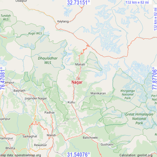
Nagar GPS coordinates[2]
32° 8' 17.088" North, 77° 10' 26.148" East
| Map corner | latitude | longitude |
|---|---|---|
| Upper-left | 32.73151°, | 76.47081° |
| Center: | 32.13808°, | 77.17393° |
| Lower-right: | 31.54076°, | 77.87706° |
| Map W x H: | 132.4×132.4 km | = 82.3×82.3mi |
| max Lat: | 34.9274° ⇑1.9% North |
| Nagar: | 32.13808° |
| min Lat: | ⇓98.1% South 8.09008° |
| min Long | Nagar | max Long |
| 68.82655° | 77.17393° | 96.81° |
| W 38.7%⇐ | ⇒61.3% E |
Elevation
Elevation of Nagar is 1693 m = 5554 ft, and this is 1397.4 m = 4585 ft above average elevation for this country.
| Max E: |
3681 m = 12077 ft | 1.3% |
| Nagar | 1693 m 5554 ft | |
| Avg. | 295.6 m = 970 ft | |
Min E: |
1 m = 3 ft | 98.7% |
See also: India elevation on elevation.city.
Geographical zone
Nagar is located in North temperate zone (between Tropic of Cancer and the Arctic Circle). Distance of this Northern Tropic circle is 967.5 km =601.2 mi to South.| Distance of | km | miles | from Nagar |
|---|---|---|---|
| North Pole | 6433.6 | 3997.7 | to North |
| Arctic Circle | 3827.8 | 2378.5 | to North |
| Tropic Cancer | 967.5 | 601.2 | to South |
| Equator | 3573.4 | 2220.4 | to South |


Nearby cities:
15 places around Nagar: (largest is in red/bold)
• Banjār
57.7 km =35.9 mi,  164°
164°
• Dharamsala
80.9 km =50.3 mi,  276°
276°
• Hamīrpur
79.4 km =49.3 mi,  230°
230°
• Jawāla Mukhi
85.7 km =53.3 mi,  249°
249°
• Jogindarnagar
40 km =24.9 mi, 245°
• Kulu
20.9 km =13 mi,  197°
197°
• Kyelang
50.2 km =31.2 mi,  343°
343°
• Kāngar
86 km =53.4 mi,  266°
266°
• Mandi
52.6 km =32.7 mi,  205°
205°
• Manāli
13.3 km =8.3 mi,  0°
0°
• Pālampur
58.2 km =36.2 mi, 267°
• Pāndoh
53.4 km =33.2 mi,  192°
192°
• Sarka Ghāt
64 km =39.8 mi,  220°
220°
• Sundarnagar
71.7 km =44.6 mi, 200°
• Tīra Sujānpur
71.6 km =44.5 mi,  241°
241°
Sources, notices
• [Note1] Compared only with cities in India existing in our database
• [Src1] Map data: © OpenStreetMap contributors (CC-BY-SA)
• [Src2] Other city data from geonames.org with taken over terms of usage.
• [Src3] Geographical zone / Annual Mean Temperature by Robert A. Rohde @ Wikipedia
