Pāndoh geodata
Pāndoh (Himachal Pradesh) is a populated place; located in India in Asia/Kolkata (GMT+5.5) time zone. With population of 4,351 people, there are 3365 cities with bigger population in this country. Compared to other cities in India, 97.3% of cities are located further ↓South; 62.5% of cities are located further →East and 94.8% of cities have lower elevation than Pāndoh. Note1


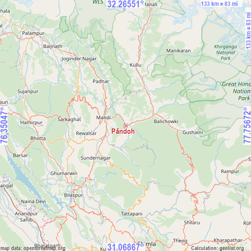
Pāndoh GPS coordinates[2]
31° 40' 8.472" North, 77° 3' 12.924" East
| Map corner | latitude | longitude |
|---|---|---|
| Upper-left | 32.26551°, | 76.35047° |
| Center: | 31.66902°, | 77.05359° |
| Lower-right: | 31.06867°, | 77.75672° |
| Map W x H: | 133.1×133.1 km | = 82.7×82.7mi |
| max Lat: | 34.9274° ⇑2.7% North |
| Pāndoh: | 31.66902° |
| min Lat: | ⇓97.3% South 8.09008° |
| min Long | Pāndoh | max Long |
| 68.82655° | 77.05359° | 96.81° |
| W 37.5%⇐ | ⇒62.5% E |
Elevation
Elevation of Pāndoh is 864 m = 2835 ft, and this is 568.4 m = 1865 ft above average elevation for this country.
| Max E: |
3681 m = 12077 ft | 5.2% |
| Pāndoh | 864 m 2835 ft | |
| Avg. | 295.6 m = 970 ft | |
Min E: |
1 m = 3 ft | 94.8% |
See also: India elevation on elevation.city.
Geographical zone
Pāndoh is located in North temperate zone (between Tropic of Cancer and the Arctic Circle). Distance of this Northern Tropic circle is 915.3 km =568.7 mi to South.| Distance of | km | miles | from Pāndoh |
|---|---|---|---|
| North Pole | 6485.8 | 4030.1 | to North |
| Arctic Circle | 3879.9 | 2410.9 | to North |
| Tropic Cancer | 915.3 | 568.7 | to South |
| Equator | 3521.3 | 2188 | to South |


Nearby cities:
15 places around Pāndoh: (largest is in red/bold)
• Arki
58.1 km =36.1 mi,  188°
188°
• Banjār
27.4 km =17 mi,  97°
97°
• Bilaspur
47 km =29.2 mi,  216°
216°
• Ghumārwīn
40.8 km =25.4 mi,  231°
231°
• Hamīrpur
50 km =31.1 mi,  271°
271°
• Jogindarnagar
43.3 km =26.9 mi,  324°
324°
• Kulu
32.6 km =20.3 mi,  9°
9°
• Mandi
12.4 km =7.7 mi,  292°
292°
• Nagar
53.4 km =33.2 mi, 12°
• Nārkanda
59.9 km =37.2 mi,  139°
139°
• Rāmpur
59.9 km =37.2 mi,  114°
114°
• Sarka Ghāt
30.3 km =18.8 mi,  276°
276°
• Seoni
48 km =29.8 mi,  172°
172°
• Sundarnagar
20.5 km =12.7 mi, 223°
• Tīra Sujānpur
55 km =34.2 mi, 289°
Sources, notices
• [Note1] Compared only with cities in India existing in our database
• [Src1] Map data: © OpenStreetMap contributors (CC-BY-SA)
• [Src2] Other city data from geonames.org with taken over terms of usage.
• [Src3] Geographical zone / Annual Mean Temperature by Robert A. Rohde @ Wikipedia
