Kulu geodata
Kulu (Himachal Pradesh) is a populated place; located in India in Asia/Kolkata (GMT+5.5) time zone. With population of 19,831 people, there are 2055 cities with bigger population in this country. Compared to other cities in India, 97.8% of cities are located further ↓South; 61.9% of cities are located further →East and 97% of cities have lower elevation than Kulu. Note1


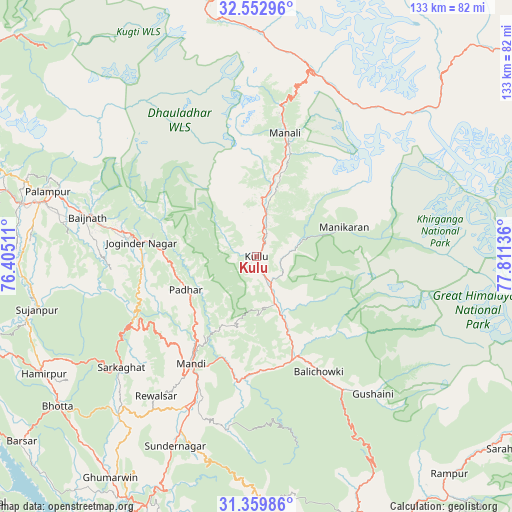
Kulu GPS coordinates[2]
31° 57' 30.06" North, 77° 6' 29.628" East
| Map corner | latitude | longitude |
|---|---|---|
| Upper-left | 32.55296°, | 76.40511° |
| Center: | 31.95835°, | 77.10823° |
| Lower-right: | 31.35986°, | 77.81136° |
| Map W x H: | 132.7×132.7 km | = 82.5×82.5mi |
| max Lat: | 34.9274° ⇑2.2% North |
| Kulu: | 31.95835° |
| min Lat: | ⇓97.8% South 8.09008° |
| min Long | Kulu | max Long |
| 68.82655° | 77.10823° | 96.81° |
| W 38.1%⇐ | ⇒61.9% E |
Elevation
Elevation of Kulu is 1240 m = 4068 ft, and this is 944.4 m = 3098 ft above average elevation for this country.
| Max E: |
3681 m = 12077 ft | 3% |
| Kulu | 1240 m 4068 ft | |
| Avg. | 295.6 m = 970 ft | |
Min E: |
1 m = 3 ft | 97% |
See also: India elevation on elevation.city.
Geographical zone
Kulu is located in North temperate zone (between Tropic of Cancer and the Arctic Circle). Distance of this Northern Tropic circle is 947.5 km =588.7 mi to South.| Distance of | km | miles | from Kulu |
|---|---|---|---|
| North Pole | 6453.6 | 4010.1 | to North |
| Arctic Circle | 3847.7 | 2390.8 | to North |
| Tropic Cancer | 947.5 | 588.7 | to South |
| Equator | 3553.4 | 2208 | to South |


Nearby cities:
15 places around Kulu: (largest is in red/bold)
• Banjār
41.7 km =25.9 mi,  148°
148°
• Ghumārwīn
68.4 km =42.5 mi,  212°
212°
• Hamīrpur
63 km =39.1 mi,  241°
241°
• Jawāla Mukhi
75 km =46.6 mi,  262°
262°
• Jogindarnagar
30.3 km =18.8 mi,  276°
276°
• Kyelang
68.7 km =42.7 mi,  353°
353°
• Mandi
32 km =19.9 mi, 211°
• Manāli
33.8 km =21 mi,  10°
10°
• Nagar
20.9 km =13 mi,  17°
17°
• Nādaun
74.8 km =46.5 mi,  254°
254°
• Pālampur
54.8 km =34.1 mi,  288°
288°
• Pāndoh
32.6 km =20.3 mi,  189°
189°
• Sarka Ghāt
45.5 km =28.3 mi,  230°
230°
• Sundarnagar
50.8 km =31.6 mi,  202°
202°
• Tīra Sujānpur
58.6 km =36.4 mi, 256°
Sources, notices
• [Note1] Compared only with cities in India existing in our database
• [Src1] Map data: © OpenStreetMap contributors (CC-BY-SA)
• [Src2] Other city data from geonames.org with taken over terms of usage.
• [Src3] Geographical zone / Annual Mean Temperature by Robert A. Rohde @ Wikipedia
