Sarka Ghāt geodata
Sarka Ghāt (Himachal Pradesh) is a populated place; located in India in Asia/Kolkata (GMT+5.5) time zone. With population of 3,944 people, there are 3384 cities with bigger population in this country. Compared to other cities in India, 97.3% of cities are located further ↓South; 65.8% of cities are located further →East and 95.9% of cities have lower elevation than Sarka Ghāt. Note1


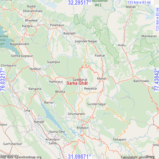
Sarka Ghāt GPS coordinates[2]
31° 41' 55.932" North, 76° 44' 7.044" East
| Map corner | latitude | longitude |
|---|---|---|
| Upper-left | 32.29517°, | 76.03217° |
| Center: | 31.69887°, | 76.73529° |
| Lower-right: | 31.09871°, | 77.43842° |
| Map W x H: | 133×133 km | = 82.6×82.6mi |
| max Lat: | 34.9274° ⇑2.7% North |
| Sarka Ghāt: | 31.69887° |
| min Lat: | ⇓97.3% South 8.09008° |
| min Long | Sarka Ghāt | max Long |
| 68.82655° | 76.73529° | 96.81° |
| W 34.2%⇐ | ⇒65.8% E |
Elevation
Elevation of Sarka Ghāt is 958 m = 3143 ft, and this is 662.4 m = 2173 ft above average elevation for this country.
| Max E: |
3681 m = 12077 ft | 4.1% |
| Sarka Ghāt | 958 m 3143 ft | |
| Avg. | 295.6 m = 970 ft | |
Min E: |
1 m = 3 ft | 95.9% |
See also: India elevation on elevation.city.
Geographical zone
Sarka Ghāt is located in North temperate zone (between Tropic of Cancer and the Arctic Circle). Distance of this Northern Tropic circle is 918.7 km =570.9 mi to South.| Distance of | km | miles | from Sarka Ghāt |
|---|---|---|---|
| North Pole | 6482.5 | 4028 | to North |
| Arctic Circle | 3876.6 | 2408.8 | to North |
| Tropic Cancer | 918.7 | 570.9 | to South |
| Equator | 3524.6 | 2190.1 | to South |


Nearby cities:
15 places around Sarka Ghāt: (largest is in red/bold)
• Bilaspur
41 km =25.5 mi,  177°
177°
• Dera Gopipur
52.8 km =32.8 mi,  292°
292°
• Ghumārwīn
28.7 km =17.8 mi, 183°
• Hamīrpur
20 km =12.4 mi,  265°
265°
• Jawāla Mukhi
43.8 km =27.2 mi,  296°
296°
• Jogindarnagar
32.5 km =20.2 mi,  8°
8°
• Kulu
45.5 km =28.3 mi,  50°
50°
• Mandi
18.7 km =11.6 mi,  85°
85°
• Nangal
48.4 km =30.1 mi,  224°
224°
• Nādaun
38.2 km =23.7 mi,  284°
284°
• Pālampur
49.2 km =30.6 mi,  339°
339°
• Pāndoh
30.3 km =18.8 mi,  96°
96°
• Sundarnagar
24.3 km =15.1 mi,  138°
138°
• Tīra Sujānpur
26.4 km =16.4 mi, 304°
• Una
51.2 km =31.8 mi,  239°
239°
Sources, notices
• [Note1] Compared only with cities in India existing in our database
• [Src1] Map data: © OpenStreetMap contributors (CC-BY-SA)
• [Src2] Other city data from geonames.org with taken over terms of usage.
• [Src3] Geographical zone / Annual Mean Temperature by Robert A. Rohde @ Wikipedia
