Kāngar geodata
Kāngar (Himachal Pradesh) is a populated place; located in India in Asia/Kolkata (GMT+5.5) time zone. With population of 9,158 people, there are 3022 cities with bigger population in this country. Compared to other cities in India, 98.1% of cities are located further ↓South; 71% of cities are located further →East and 92.4% of cities have lower elevation than Kāngar. Note1


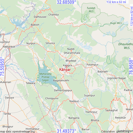
Kāngar GPS coordinates[2]
32° 5' 28.86" North, 76° 15' 45.612" East
| Map corner | latitude | longitude |
|---|---|---|
| Upper-left | 32.68509°, | 75.55955° |
| Center: | 32.09135°, | 76.26267° |
| Lower-right: | 31.49373°, | 76.9658° |
| Map W x H: | 132.5×132.5 km | = 82.3×82.3mi |
| max Lat: | 34.9274° ⇑1.9% North |
| Kāngar: | 32.09135° |
| min Lat: | ⇓98.1% South 8.09008° |
| min Long | Kāngar | max Long |
| 68.82655° | 76.26267° | 96.81° |
| W 29%⇐ | ⇒71% E |
Elevation
Elevation of Kāngar is 697 m = 2287 ft, and this is 401.4 m = 1317 ft above average elevation for this country.
| Max E: |
3681 m = 12077 ft | 7.6% |
| Kāngar | 697 m 2287 ft | |
| Avg. | 295.6 m = 970 ft | |
Min E: |
1 m = 3 ft | 92.4% |
See also: India elevation on elevation.city.
Geographical zone
Kāngar is located in North temperate zone (between Tropic of Cancer and the Arctic Circle). Distance of this Northern Tropic circle is 962.3 km =597.9 mi to South.| Distance of | km | miles | from Kāngar |
|---|---|---|---|
| North Pole | 6438.8 | 4000.9 | to North |
| Arctic Circle | 3833 | 2381.7 | to North |
| Tropic Cancer | 962.3 | 597.9 | to South |
| Equator | 3568.2 | 2217.2 | to South |


Nearby cities:
15 places around Kāngar: (largest is in red/bold)
• Chowari
44.6 km =27.7 mi,  328°
328°
• Chuāri Khās
44.4 km =27.6 mi, 328°
• Daulatpur
3.9 km =2.4 mi,  182°
182°
• Daulatpur
42.3 km =26.3 mi,  217°
217°
• Dera Gopipur
24 km =14.9 mi,  189°
189°
• Dharamsala
15.3 km =9.5 mi,  20°
20°
• Hājipur
49.6 km =30.8 mi,  255°
255°
• Jawāla Mukhi
24.7 km =15.3 mi,  167°
167°
• Kotla
27.9 km =17.3 mi,  309°
309°
• Nagrota
16.6 km =10.3 mi, 256°
• Nādaun
35.1 km =21.8 mi, 167°
• Pālampur
27.8 km =17.3 mi,  84°
84°
• Talwāra
39.4 km =24.5 mi,  244°
244°
• Tīra Sujānpur
36.7 km =22.8 mi,  141°
141°
• Yol
10.2 km =6.3 mi,  322°
322°
Sources, notices
• [Note1] Compared only with cities in India existing in our database
• [Src1] Map data: © OpenStreetMap contributors (CC-BY-SA)
• [Src2] Other city data from geonames.org with taken over terms of usage.
• [Src3] Geographical zone / Annual Mean Temperature by Robert A. Rohde @ Wikipedia
