Hamīrpur geodata
Hamīrpur (Himachal Pradesh) is a populated place; located in India in Asia/Kolkata (GMT+5.5) time zone. With population of 19,280 people, there are 2101 cities with bigger population in this country. Compared to other cities in India, 97.3% of cities are located further ↓South; 68.1% of cities are located further →East and 93.4% of cities have lower elevation than Hamīrpur. Note1


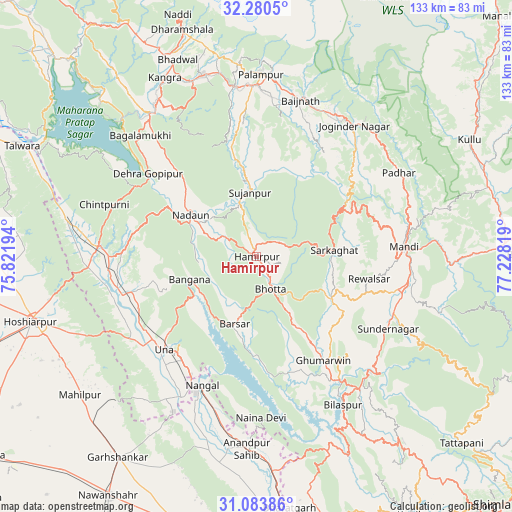
Hamīrpur GPS coordinates[2]
31° 41' 2.796" North, 76° 31' 30.216" East
| Map corner | latitude | longitude |
|---|---|---|
| Upper-left | 32.2805°, | 75.82194° |
| Center: | 31.68411°, | 76.52506° |
| Lower-right: | 31.08386°, | 77.22819° |
| Map W x H: | 133.1×133.1 km | = 82.7×82.7mi |
| max Lat: | 34.9274° ⇑2.7% North |
| Hamīrpur: | 31.68411° |
| min Lat: | ⇓97.3% South 8.09008° |
| min Long | Hamīrpur | max Long |
| 68.82655° | 76.52506° | 96.81° |
| W 31.9%⇐ | ⇒68.1% E |
Elevation
Elevation of Hamīrpur is 768 m = 2520 ft, and this is 472.4 m = 1550 ft above average elevation for this country.
| Max E: |
3681 m = 12077 ft | 6.6% |
| Hamīrpur | 768 m 2520 ft | |
| Avg. | 295.6 m = 970 ft | |
Min E: |
1 m = 3 ft | 93.4% |
See also: India elevation on elevation.city.
Geographical zone
Hamīrpur is located in North temperate zone (between Tropic of Cancer and the Arctic Circle). Distance of this Northern Tropic circle is 917 km =569.8 mi to South.| Distance of | km | miles | from Hamīrpur |
|---|---|---|---|
| North Pole | 6484.1 | 4029 | to North |
| Arctic Circle | 3878.2 | 2409.8 | to North |
| Tropic Cancer | 917 | 569.8 | to South |
| Equator | 3522.9 | 2189 | to South |


Nearby cities:
15 places around Hamīrpur: (largest is in red/bold)
• Bilaspur
45.1 km =28 mi,  150°
150°
• Dera Gopipur
36.2 km =22.5 mi,  306°
306°
• Gagret
44 km =27.3 mi,  266°
266°
• Ghumārwīn
32.4 km =20.1 mi, 146°
• Jawāla Mukhi
28.7 km =17.8 mi,  317°
317°
• Jogindarnagar
41.9 km =26 mi,  36°
36°
• Mandi
38.7 km =24 mi,  85°
85°
• Nangal
35.7 km =22.2 mi,  203°
203°
• Nādaun
20.4 km =12.7 mi,  302°
302°
• Pālampur
48 km =29.8 mi,  3°
3°
• Santokhgarh
41.8 km =26 mi,  208°
208°
• Sarka Ghāt
20 km =12.4 mi, 85°
• Sundarnagar
39.6 km =24.6 mi,  114°
114°
• Tīra Sujānpur
16.7 km =10.4 mi,  353°
353°
• Una
34.4 km =21.4 mi,  224°
224°
Sources, notices
• [Note1] Compared only with cities in India existing in our database
• [Src1] Map data: © OpenStreetMap contributors (CC-BY-SA)
• [Src2] Other city data from geonames.org with taken over terms of usage.
• [Src3] Geographical zone / Annual Mean Temperature by Robert A. Rohde @ Wikipedia
