Kyelang geodata
Kyelang (Himachal Pradesh) is a populated place; located in India in Asia/Kolkata (GMT+5.5) time zone. With population of 14,182 people, there are 2545 cities with bigger population in this country. Compared to other cities in India, 98.6% of cities are located further ↓South; 62.9% of cities are located further →East and 99.9% of cities have lower elevation than Kyelang. Note1


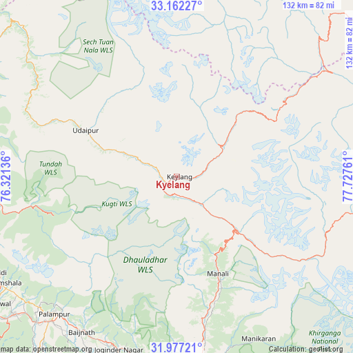
Kyelang GPS coordinates[2]
32° 34' 18.12" North, 77° 1' 28.128" East
| Map corner | latitude | longitude |
|---|---|---|
| Upper-left | 33.16227°, | 76.32136° |
| Center: | 32.5717°, | 77.02448° |
| Lower-right: | 31.97721°, | 77.72761° |
| Map W x H: | 131.8×131.8 km | = 81.9×81.9mi |
| max Lat: | 34.9274° ⇑1.4% North |
| Kyelang: | 32.5717° |
| min Lat: | ⇓98.6% South 8.09008° |
| min Long | Kyelang | max Long |
| 68.82655° | 77.02448° | 96.81° |
| W 37.1%⇐ | ⇒62.9% E |
Elevation
Elevation of Kyelang is 3038 m = 9967 ft, and this is 2742.4 m = 8997 ft above average elevation for this country.
| Max E: |
3681 m = 12077 ft | 0.099999999999994% |
| Kyelang | 3038 m 9967 ft | |
| Avg. | 295.6 m = 970 ft | |
Min E: |
1 m = 3 ft | 99.9% |
See also: India elevation on elevation.city.
Geographical zone
Kyelang is located in North temperate zone (between Tropic of Cancer and the Arctic Circle). Distance of this Northern Tropic circle is 1015.7 km =631.1 mi to South.| Distance of | km | miles | from Kyelang |
|---|---|---|---|
| North Pole | 6385.4 | 3967.7 | to North |
| Arctic Circle | 3779.5 | 2348.5 | to North |
| Tropic Cancer | 1015.7 | 631.1 | to South |
| Equator | 3621.6 | 2250.4 | to South |


Nearby cities:
15 places around Kyelang: (largest is in red/bold)
• Chamba
84.2 km =52.3 mi,  268°
268°
• Chowari
96.2 km =59.8 mi,  260°
260°
• Chuāri Khās
96 km =59.7 mi, 260°
• Daulatpur
91.8 km =57 mi,  231°
231°
• Dharamsala
76.8 km =47.7 mi,  239°
239°
• Jogindarnagar
68.6 km =42.6 mi,  198°
198°
• Kotla
99.7 km =62 mi,  248°
248°
• Kulu
68.7 km =42.7 mi,  173°
173°
• Kāngar
89.3 km =55.5 mi, 233°
• Mandi
96 km =59.7 mi,  185°
185°
• Manāli
37.7 km =23.4 mi,  158°
158°
• Nagar
50.2 km =31.2 mi, 163°
• Pālampur
67.2 km =41.8 mi,  220°
220°
• Tīra Sujānpur
95.5 km =59.3 mi,  210°
210°
• Yol
90 km =55.9 mi, 239°
Sources, notices
• [Note1] Compared only with cities in India existing in our database
• [Src1] Map data: © OpenStreetMap contributors (CC-BY-SA)
• [Src2] Other city data from geonames.org with taken over terms of usage.
• [Src3] Geographical zone / Annual Mean Temperature by Robert A. Rohde @ Wikipedia
