Banjār geodata
Banjār (Himachal Pradesh) is a populated place; located in India in Asia/Kolkata (GMT+5.5) time zone. With population of 1,351 people, there are 3453 cities with bigger population in this country. Compared to other cities in India, 97.2% of cities are located further ↓South; 59.1% of cities are located further →East and 97.6% of cities have lower elevation than Banjār. Note1


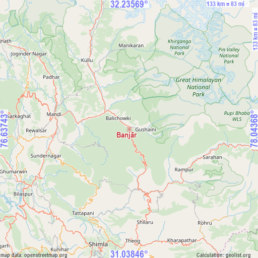
Banjār GPS coordinates[2]
31° 38' 20.4" North, 77° 20' 25.98" East
| Map corner | latitude | longitude |
|---|---|---|
| Upper-left | 32.23569°, | 76.63743° |
| Center: | 31.639°, | 77.34055° |
| Lower-right: | 31.03846°, | 78.04368° |
| Map W x H: | 133.1×133.1 km | = 82.7×82.7mi |
| max Lat: | 34.9274° ⇑2.8% North |
| Banjār: | 31.639° |
| min Lat: | ⇓97.2% South 8.09008° |
| min Long | Banjār | max Long |
| 68.82655° | 77.34055° | 96.81° |
| W 40.9%⇐ | ⇒59.1% E |
Elevation
Elevation of Banjār is 1442 m = 4731 ft, and this is 1146.4 m = 3761 ft above average elevation for this country.
| Max E: |
3681 m = 12077 ft | 2.4% |
| Banjār | 1442 m 4731 ft | |
| Avg. | 295.6 m = 970 ft | |
Min E: |
1 m = 3 ft | 97.6% |
See also: India elevation on elevation.city.
Geographical zone
Banjār is located in North temperate zone (between Tropic of Cancer and the Arctic Circle). Distance of this Northern Tropic circle is 912 km =566.7 mi to South.| Distance of | km | miles | from Banjār |
|---|---|---|---|
| North Pole | 6489.1 | 4032.1 | to North |
| Arctic Circle | 3883.2 | 2412.9 | to North |
| Tropic Cancer | 912 | 566.7 | to South |
| Equator | 3517.9 | 2185.9 | to South |


Nearby cities:
15 places around Banjār: (largest is in red/bold)
• Ghumārwīn
63.2 km =39.3 mi,  249°
249°
• Kotkhai
61 km =37.9 mi,  161°
161°
• Kulu
41.7 km =25.9 mi,  328°
328°
• Mandi
39.4 km =24.5 mi,  281°
281°
• Nagar
57.7 km =35.9 mi,  344°
344°
• Nārkanda
44 km =27.3 mi, 164°
• Pāndoh
27.4 km =17 mi, 277°
• Rohru
62.4 km =38.8 mi,  140°
140°
• Rāmpur
34.7 km =21.6 mi,  127°
127°
• Sarka Ghāt
57.7 km =35.9 mi, 276°
• Sarāhan
45.3 km =28.1 mi,  108°
108°
• Seoni
48.7 km =30.3 mi,  204°
204°
• Shimla
61.7 km =38.3 mi, 195°
• Sundarnagar
42.8 km =26.6 mi, 254°
• Theog
57.6 km =35.8 mi,  178°
178°
Sources, notices
• [Note1] Compared only with cities in India existing in our database
• [Src1] Map data: © OpenStreetMap contributors (CC-BY-SA)
• [Src2] Other city data from geonames.org with taken over terms of usage.
• [Src3] Geographical zone / Annual Mean Temperature by Robert A. Rohde @ Wikipedia
