Kānke geodata
Kānke (Jharkhand) is a populated place; located in India in Asia/Kolkata (GMT+5.5) time zone. With population of 16,712 people, there are 2313 cities with bigger population in this country. Compared to other cities in India, 54.5% of cities are located further ↓South; 85.1% of cities are located further ←West and 90.3% of cities have lower elevation than Kānke. Note1


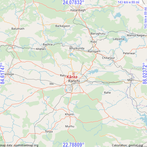
Kānke GPS coordinates[2]
23° 26' 5.208" North, 85° 19' 14.124" East
| Map corner | latitude | longitude |
|---|---|---|
| Upper-left | 24.07832°, | 84.61747° |
| Center: | 23.43478°, | 85.32059° |
| Lower-right: | 22.78809°, | 86.02372° |
| Map W x H: | 143.5×143.5 km | = 89.2×89.2mi |
| max Lat: | 34.9274° ⇑45.5% North |
| Kānke: | 23.43478° |
| min Lat: | ⇓54.5% South 8.09008° |
| min Long | Kānke | max Long |
| 68.82655° | 85.32059° | 96.81° |
| W 85.1%⇐ | ⇒14.9% E |
Elevation
Elevation of Kānke is 643 m = 2110 ft, and this is 347.4 m = 1140 ft above average elevation for this country.
| Max E: |
3681 m = 12077 ft | 9.7% |
| Kānke | 643 m 2110 ft | |
| Avg. | 295.6 m = 970 ft | |
Min E: |
1 m = 3 ft | 90.3% |
See also: India elevation on elevation.city.
Geographical zone
Kānke is located in North Torrid zone (between Equator and Tropic of Cancer). Distance of this Northern Tropic circle is 0.2 km =0.1 mi to North.| Distance of | km | miles | from Kānke |
|---|---|---|---|
| North Pole | 7401.4 | 4599 | to North |
| Arctic Circle | 4795.5 | 2979.8 | to North |
| Tropic Cancer | 0.2 | 0.1 | to North |
| Equator | 2605.7 | 1619.1 | to South |


Nearby cities:
15 places around Kānke: (largest is in red/bold)
• Barkā Kānā
25.6 km =15.9 mi,  35°
35°
• Bokāro
75.7 km =47 mi,  58°
58°
• Būndu
41 km =25.5 mi,  137°
137°
• Gumia
65.3 km =40.6 mi,  51°
51°
• Hazāribāgh
62.1 km =38.6 mi,  3°
3°
• Jhalidā
67.4 km =41.9 mi,  96°
96°
• Kharsāwān
88.6 km =55.1 mi, 143°
• Khunti
40.1 km =24.9 mi,  186°
186°
• Kuju
37.6 km =23.4 mi,  30°
30°
• Lohārdagā
65.4 km =40.6 mi,  269°
269°
• Muri
55.7 km =34.6 mi, 97°
• Ranchi
10.3 km =6.4 mi, 186°
• Rāmgarh
29.9 km =18.6 mi, 43°
• Rāy
38.8 km =24.1 mi,  315°
315°
• Sāruberā
81 km =50.3 mi, 58°
Sources, notices
• [Note1] Compared only with cities in India existing in our database
• [Src1] Map data: © OpenStreetMap contributors (CC-BY-SA)
• [Src2] Other city data from geonames.org with taken over terms of usage.
• [Src3] Geographical zone / Annual Mean Temperature by Robert A. Rohde @ Wikipedia
