Kuju geodata
Kuju (Jharkhand) is a populated place; located in India in Asia/Kolkata (GMT+5.5) time zone. With population of 19,390 people, there are 2087 cities with bigger population in this country. Compared to other cities in India, 56.2% of cities are located further ↓South; 85.6% of cities are located further ←West and 77.5% of cities have lower elevation than Kuju. Note1


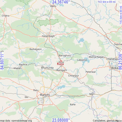
Kuju GPS coordinates[2]
23° 43' 31.296" North, 85° 30' 36.828" East
| Map corner | latitude | longitude |
|---|---|---|
| Upper-left | 24.36746°, | 84.80711° |
| Center: | 23.72536°, | 85.51023° |
| Lower-right: | 23.08008°, | 86.21336° |
| Map W x H: | 143.1×143.1 km | = 88.9×88.9mi |
| max Lat: | 34.9274° ⇑43.8% North |
| Kuju: | 23.72536° |
| min Lat: | ⇓56.2% South 8.09008° |
| min Long | Kuju | max Long |
| 68.82655° | 85.51023° | 96.81° |
| W 85.6%⇐ | ⇒14.4% E |
Elevation
Elevation of Kuju is 423 m = 1388 ft, and this is 127.4 m = 418 ft above average elevation for this country.
| Max E: |
3681 m = 12077 ft | 22.5% |
| Kuju | 423 m 1388 ft | |
| Avg. | 295.6 m = 970 ft | |
Min E: |
1 m = 3 ft | 77.5% |
See also: India elevation on elevation.city.
Geographical zone
Kuju is located in North temperate zone (between Tropic of Cancer and the Arctic Circle). Distance of this Northern Tropic circle is 32.1 km =19.9 mi to South.| Distance of | km | miles | from Kuju |
|---|---|---|---|
| North Pole | 7369 | 4578.9 | to North |
| Arctic Circle | 4763.2 | 2959.7 | to North |
| Tropic Cancer | 32.1 | 19.9 | to South |
| Equator | 2638 | 1639.2 | to South |


Nearby cities:
15 places around Kuju: (largest is in red/bold)
• Barki Saria
63.2 km =39.3 mi,  37°
37°
• Barkā Kānā
12.4 km =7.7 mi,  200°
200°
• Bokāro
45.9 km =28.5 mi,  81°
81°
• Būndu
63.3 km =39.3 mi,  172°
172°
• Gumia
33 km =20.5 mi, 75°
• Hazāribāgh
33.3 km =20.7 mi,  333°
333°
• Hesla
53.1 km =33 mi, 44°
• Jhalidā
62.1 km =38.6 mi,  130°
130°
• Kānke
37.6 km =23.4 mi,  210°
210°
• Muri
53.3 km =33.1 mi,  137°
137°
• Ranchi
47.2 km =29.3 mi, 205°
• Rāmgarh
10.6 km =6.6 mi, 173°
• Rāy
46.6 km =29 mi,  264°
264°
• Sāruberā
50.5 km =31.4 mi, 78°
• patamda
64.6 km =40.1 mi,  351°
351°
Sources, notices
• [Note1] Compared only with cities in India existing in our database
• [Src1] Map data: © OpenStreetMap contributors (CC-BY-SA)
• [Src2] Other city data from geonames.org with taken over terms of usage.
• [Src3] Geographical zone / Annual Mean Temperature by Robert A. Rohde @ Wikipedia
