Ranchi geodata
Ranchi (Jharkhand) is a seat of a first-order administrative division; located in India in Asia/Kolkata (GMT+5.5) time zone. With population of 846,454 people, there are 53 cities with bigger population in this country. Compared to other cities in India, 54% of cities are located further ↓South; 85.1% of cities are located further ←West and 90.3% of cities have lower elevation than Ranchi. Note1


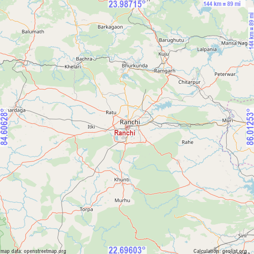
Ranchi GPS coordinates[2]
23° 20' 35.376" North, 85° 18' 33.84" East
| Map corner | latitude | longitude |
|---|---|---|
| Upper-left | 23.98715°, | 84.60628° |
| Center: | 23.34316°, | 85.3094° |
| Lower-right: | 22.69603°, | 86.01253° |
| Map W x H: | 143.6×143.6 km | = 89.2×89.2mi |
| max Lat: | 34.9274° ⇑46% North |
| Ranchi: | 23.34316° |
| min Lat: | ⇓54% South 8.09008° |
| min Long | Ranchi | max Long |
| 68.82655° | 85.3094° | 96.81° |
| W 85.1%⇐ | ⇒14.9% E |
Elevation
Elevation of Ranchi is 643 m = 2110 ft, and this is 347.4 m = 1140 ft above average elevation for this country.
| Max E: |
3681 m = 12077 ft | 9.7% |
| Ranchi | 643 m 2110 ft | |
| Avg. | 295.6 m = 970 ft | |
Min E: |
1 m = 3 ft | 90.3% |
See also: Ranchi elevation on elevation.city.
Geographical zone
Ranchi is located in North Torrid zone (between Equator and Tropic of Cancer). Distance of this Northern Tropic circle is 10.4 km =6.5 mi to North.| Distance of | km | miles | from Ranchi |
|---|---|---|---|
| North Pole | 7411.5 | 4605.3 | to North |
| Arctic Circle | 4805.7 | 2986.1 | to North |
| Tropic Cancer | 10.4 | 6.5 | to North |
| Equator | 2595.5 | 1612.8 | to South |


Nearby cities:
15 places around Ranchi: (largest is in red/bold)
• Barkā Kānā
34.9 km =21.7 mi,  27°
27°
• Bokāro
82.4 km =51.2 mi,  53°
53°
• Būndu
35.1 km =21.8 mi,  125°
125°
• Chakradharpur
81.1 km =50.4 mi,  156°
156°
• Gumia
72.9 km =45.3 mi, 46°
• Hazāribāgh
72.4 km =45 mi,  4°
4°
• Jhalidā
68.1 km =42.3 mi,  87°
87°
• Kharsāwān
81.3 km =50.5 mi,  139°
139°
• Khunti
29.9 km =18.6 mi,  186°
186°
• Kuju
47.2 km =29.3 mi, 25°
• Kānke
10.3 km =6.4 mi,  6°
6°
• Lohārdagā
65 km =40.4 mi,  278°
278°
• Muri
56.5 km =35.1 mi, 86°
• Rāmgarh
38.6 km =24 mi, 34°
• Rāy
46 km =28.6 mi,  325°
325°
Sources, notices
• [Note1] Compared only with cities in India existing in our database
• [Src1] Map data: © OpenStreetMap contributors (CC-BY-SA)
• [Src2] Other city data from geonames.org with taken over terms of usage.
• [Src3] Geographical zone / Annual Mean Temperature by Robert A. Rohde @ Wikipedia
