Moth geodata
Moth (Uttar Pradesh) is a populated place; located in India in Asia/Kolkata (GMT+5.5) time zone. With population of 14,077 people, there are 2557 cities with bigger population in this country. Compared to other cities in India, 68.6% of cities are located further ↓South; 58.7% of cities are located further ←West and 54.3% of cities have higher elevation than Moth. Note1


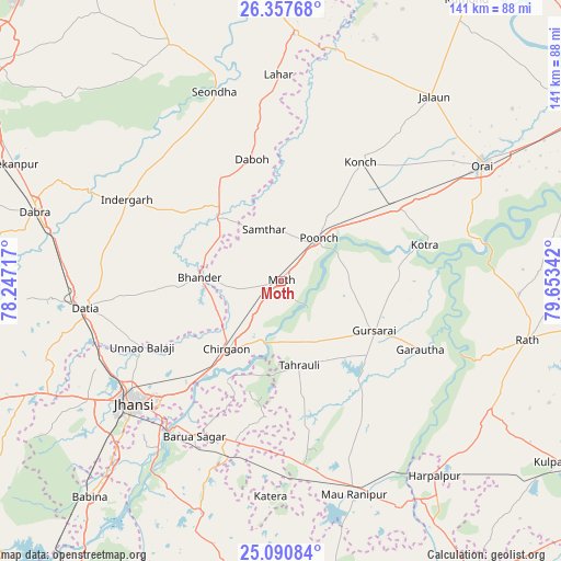
Moth GPS coordinates[2]
25° 43' 33.42" North, 78° 57' 1.044" East
| Map corner | latitude | longitude |
|---|---|---|
| Upper-left | 26.35768°, | 78.24717° |
| Center: | 25.72595°, | 78.95029° |
| Lower-right: | 25.09084°, | 79.65342° |
| Map W x H: | 140.9×140.9 km | = 87.6×87.6mi |
| max Lat: | 34.9274° ⇑31.4% North |
| Moth: | 25.72595° |
| min Lat: | ⇓68.6% South 8.09008° |
| min Long | Moth | max Long |
| 68.82655° | 78.95029° | 96.81° |
| W 58.7%⇐ | ⇒41.3% E |
Elevation
Elevation of Moth is 179 m = 587 ft, and this is 116.6 m = 383 ft below average elevation for this country.
| Max E: |
3681 m = 12077 ft | 54.3% |
| Avg. | 295.6 m = 970 ft | |
| Moth | 179 m = 587 ft | |
Min E: |
1 m = 3 ft | 45.7% |
See also: India elevation on elevation.city.
Geographical zone
Moth is located in North temperate zone (between Tropic of Cancer and the Arctic Circle). Distance of this Northern Tropic circle is 254.5 km =158.1 mi to South.| Distance of | km | miles | from Moth |
|---|---|---|---|
| North Pole | 7146.6 | 4440.7 | to North |
| Arctic Circle | 4540.7 | 2821.5 | to North |
| Tropic Cancer | 254.5 | 158.1 | to South |
| Equator | 2860.5 | 1777.4 | to South |


Nearby cities:
15 places around Moth: (largest is in red/bold)
• Alampur
36.6 km =22.7 mi,  335°
335°
• Barāgaon
36.7 km =22.8 mi,  220°
220°
• Bhānder
20.5 km =12.7 mi,  273°
273°
• Chirgaon
21.9 km =13.6 mi, 218°
• Daboh
31.6 km =19.6 mi,  346°
346°
• Datia
49.6 km =30.8 mi,  263°
263°
• Garautha
38.8 km =24.1 mi,  116°
116°
• Gursarāi
26.1 km =16.2 mi, 117°
• Jhānsi
47.6 km =29.6 mi,  231°
231°
• Konch
36 km =22.4 mi,  33°
33°
• Kotra
37.1 km =23.1 mi,  75°
75°
• Nadīgaon
43.1 km =26.8 mi,  9°
9°
• Pārīchha
30.9 km =19.2 mi, 218°
• Samthar
13.8 km =8.6 mi, 341°
• Tori-Fatehpur
34.3 km =21.3 mi,  151°
151°
Sources, notices
• [Note1] Compared only with cities in India existing in our database
• [Src1] Map data: © OpenStreetMap contributors (CC-BY-SA)
• [Src2] Other city data from geonames.org with taken over terms of usage.
• [Src3] Geographical zone / Annual Mean Temperature by Robert A. Rohde @ Wikipedia
