Datia geodata
Datia (Madhya Pradesh) is a populated place; located in India in Asia/Kolkata (GMT+5.5) time zone. With population of 90,628 people, there are 489 cities with bigger population in this country. Compared to other cities in India, 68.3% of cities are located further ↓South; 53.8% of cities are located further ←West and 59.5% of cities have lower elevation than Datia. Note1


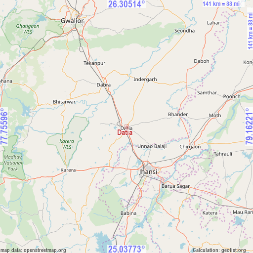
Datia GPS coordinates[2]
25° 40' 23.232" North, 78° 27' 32.688" East
| Map corner | latitude | longitude |
|---|---|---|
| Upper-left | 26.30514°, | 77.75596° |
| Center: | 25.67312°, | 78.45908° |
| Lower-right: | 25.03773°, | 79.16221° |
| Map W x H: | 140.9×140.9 km | = 87.6×87.6mi |
| max Lat: | 34.9274° ⇑31.7% North |
| Datia: | 25.67312° |
| min Lat: | ⇓68.3% South 8.09008° |
| min Long | Datia | max Long |
| 68.82655° | 78.45908° | 96.81° |
| W 53.8%⇐ | ⇒46.2% E |
Elevation
Elevation of Datia is 247 m = 810 ft, and this is 48.6 m = 159 ft below average elevation for this country.
| Max E: |
3681 m = 12077 ft | 40.5% |
| Avg. | 295.6 m = 970 ft | |
| Datia | 247 m = 810 ft | |
Min E: |
1 m = 3 ft | 59.5% |
See also: Datia elevation on elevation.city.
Geographical zone
Datia is located in North temperate zone (between Tropic of Cancer and the Arctic Circle). Distance of this Northern Tropic circle is 248.7 km =154.5 mi to South.| Distance of | km | miles | from Datia |
|---|---|---|---|
| North Pole | 7152.5 | 4444.4 | to North |
| Arctic Circle | 4546.6 | 2825.1 | to North |
| Tropic Cancer | 248.7 | 154.5 | to South |
| Equator | 2854.6 | 1773.8 | to South |


Nearby cities:
15 places around Datia: (largest is in red/bold)
• Antri
49.5 km =30.8 mi,  329°
329°
• Babīna
48.2 km =30 mi,  178°
178°
• Barāgaon
33.6 km =20.9 mi,  130°
130°
• Bhitarwār
37.3 km =23.2 mi,  290°
290°
• Bhānder
29.5 km =18.3 mi,  76°
76°
• Chirgaon
37.3 km =23.2 mi,  107°
107°
• Dabra
26.8 km =16.7 mi, 331°
• Jhānsi
26.7 km =16.6 mi,  153°
153°
• Karera
40.3 km =25 mi,  233°
233°
• Khailār
37.6 km =23.4 mi,  168°
168°
• Moth
49.6 km =30.8 mi, 83°
• Orchha
40.1 km =24.9 mi, 153°
• Pārīchha
35.3 km =21.9 mi,  121°
121°
• Samthar
48.7 km =30.3 mi,  67°
67°
• Tekanpur
39.8 km =24.7 mi, 333°
Sources, notices
• [Note1] Compared only with cities in India existing in our database
• [Src1] Map data: © OpenStreetMap contributors (CC-BY-SA)
• [Src2] Other city data from geonames.org with taken over terms of usage.
• [Src3] Geographical zone / Annual Mean Temperature by Robert A. Rohde @ Wikipedia
