Samthar geodata
Samthar (Uttar Pradesh) is a populated place; located in India in Asia/Kolkata (GMT+5.5) time zone. With population of 21,582 people, there are 1927 cities with bigger population in this country. Compared to other cities in India, 69.2% of cities are located further ↓South; 58.1% of cities are located further ←West and 54.6% of cities have higher elevation than Samthar. Note1


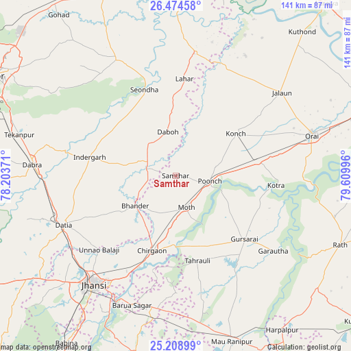
Samthar GPS coordinates[2]
25° 50' 36.528" North, 78° 54' 24.588" East
| Map corner | latitude | longitude |
|---|---|---|
| Upper-left | 26.47458°, | 78.20371° |
| Center: | 25.84348°, | 78.90683° |
| Lower-right: | 25.20899°, | 79.60996° |
| Map W x H: | 140.7×140.7 km | = 87.4×87.4mi |
| max Lat: | 34.9274° ⇑30.8% North |
| Samthar: | 25.84348° |
| min Lat: | ⇓69.2% South 8.09008° |
| min Long | Samthar | max Long |
| 68.82655° | 78.90683° | 96.81° |
| W 58.1%⇐ | ⇒41.9% E |
Elevation
Elevation of Samthar is 177 m = 581 ft, and this is 118.6 m = 389 ft below average elevation for this country.
| Max E: |
3681 m = 12077 ft | 54.6% |
| Avg. | 295.6 m = 970 ft | |
| Samthar | 177 m = 581 ft | |
Min E: |
1 m = 3 ft | 45.4% |
See also: India elevation on elevation.city.
Geographical zone
Samthar is located in North temperate zone (between Tropic of Cancer and the Arctic Circle). Distance of this Northern Tropic circle is 267.6 km =166.3 mi to South.| Distance of | km | miles | from Samthar |
|---|---|---|---|
| North Pole | 7133.5 | 4432.6 | to North |
| Arctic Circle | 4527.6 | 2813.3 | to North |
| Tropic Cancer | 267.6 | 166.3 | to South |
| Equator | 2873.5 | 1785.5 | to South |


Nearby cities:
15 places around Samthar: (largest is in red/bold)
• Alampur
23 km =14.3 mi,  331°
331°
• Barāgaon
45.3 km =28.1 mi,  205°
205°
• Bhānder
20.1 km =12.5 mi,  233°
233°
• Chirgaon
31.6 km =19.6 mi,  197°
197°
• Daboh
17.9 km =11.1 mi,  350°
350°
• Datia
48.7 km =30.3 mi,  247°
247°
• Gursarāi
37.2 km =23.1 mi,  132°
132°
• Konch
29.7 km =18.5 mi,  55°
55°
• Kotra
40.5 km =25.2 mi,  95°
95°
• Lahār
39.1 km =24.3 mi,  5°
5°
• Moth
13.8 km =8.6 mi,  161°
161°
• Nadīgaon
31.6 km =19.6 mi,  21°
21°
• Pārīchha
40.1 km =24.9 mi, 201°
• Seondha
36.8 km =22.9 mi,  340°
340°
• Tori-Fatehpur
47.9 km =29.8 mi,  154°
154°
Sources, notices
• [Note1] Compared only with cities in India existing in our database
• [Src1] Map data: © OpenStreetMap contributors (CC-BY-SA)
• [Src2] Other city data from geonames.org with taken over terms of usage.
• [Src3] Geographical zone / Annual Mean Temperature by Robert A. Rohde @ Wikipedia
