Bhānder geodata
Bhānder (Madhya Pradesh) is a populated place; located in India in Asia/Kolkata (GMT+5.5) time zone. With population of 22,482 people, there are 1879 cities with bigger population in this country. Compared to other cities in India, 68.7% of cities are located further ↓South; 56.3% of cities are located further ←West and 53.5% of cities have higher elevation than Bhānder. Note1


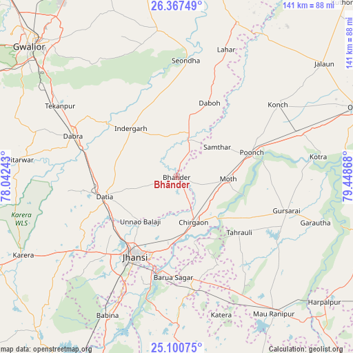
Bhānder GPS coordinates[2]
25° 44' 8.916" North, 78° 44' 43.98" East
| Map corner | latitude | longitude |
|---|---|---|
| Upper-left | 26.36749°, | 78.04243° |
| Center: | 25.73581°, | 78.74555° |
| Lower-right: | 25.10075°, | 79.44868° |
| Map W x H: | 140.8×140.8 km | = 87.5×87.5mi |
| max Lat: | 34.9274° ⇑31.3% North |
| Bhānder: | 25.73581° |
| min Lat: | ⇓68.7% South 8.09008° |
| min Long | Bhānder | max Long |
| 68.82655° | 78.74555° | 96.81° |
| W 56.3%⇐ | ⇒43.7% E |
Elevation
Elevation of Bhānder is 182 m = 597 ft, and this is 113.6 m = 373 ft below average elevation for this country.
| Max E: |
3681 m = 12077 ft | 53.5% |
| Avg. | 295.6 m = 970 ft | |
| Bhānder | 182 m = 597 ft | |
Min E: |
1 m = 3 ft | 46.5% |
See also: India elevation on elevation.city.
Geographical zone
Bhānder is located in North temperate zone (between Tropic of Cancer and the Arctic Circle). Distance of this Northern Tropic circle is 255.6 km =158.8 mi to South.| Distance of | km | miles | from Bhānder |
|---|---|---|---|
| North Pole | 7145.5 | 4440 | to North |
| Arctic Circle | 4539.6 | 2820.8 | to North |
| Tropic Cancer | 255.6 | 158.8 | to South |
| Equator | 2861.6 | 1778.1 | to South |


Nearby cities:
15 places around Bhānder: (largest is in red/bold)
• Alampur
32.6 km =20.3 mi,  9°
9°
• Barāgaon
29.1 km =18.1 mi,  186°
186°
• Chirgaon
19.5 km =12.1 mi,  159°
159°
• Daboh
32.4 km =20.1 mi,  23°
23°
• Dabra
44.6 km =27.7 mi,  291°
291°
• Datia
29.5 km =18.3 mi,  256°
256°
• Gursarāi
45.6 km =28.3 mi,  106°
106°
• Jhānsi
35 km =21.7 mi,  208°
208°
• Khailār
48.9 km =30.4 mi, 206°
• Moth
20.5 km =12.7 mi,  93°
93°
• Orchha
44 km =27.3 mi, 193°
• Pārīchha
25.4 km =15.8 mi,  176°
176°
• Samthar
20.1 km =12.5 mi,  53°
53°
• Seondha
46.7 km =29 mi,  4°
4°
• Tori-Fatehpur
48.4 km =30.1 mi,  130°
130°
Sources, notices
• [Note1] Compared only with cities in India existing in our database
• [Src1] Map data: © OpenStreetMap contributors (CC-BY-SA)
• [Src2] Other city data from geonames.org with taken over terms of usage.
• [Src3] Geographical zone / Annual Mean Temperature by Robert A. Rohde @ Wikipedia
