Tori-Fatehpur geodata
Tori-Fatehpur (Uttar Pradesh) is a populated place; located in India in Asia/Kolkata (GMT+5.5) time zone. With population of 10,210 people, there are 2922 cities with bigger population in this country. Compared to other cities in India, 66.5% of cities are located further ↓South; 60% of cities are located further ←West and 53.5% of cities have higher elevation than Tori-Fatehpur. Note1


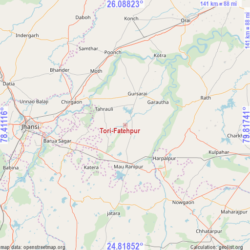
Tori-Fatehpur GPS coordinates[2]
25° 27' 18.18" North, 79° 6' 51.408" East
| Map corner | latitude | longitude |
|---|---|---|
| Upper-left | 26.08823°, | 78.41116° |
| Center: | 25.45505°, | 79.11428° |
| Lower-right: | 24.81852°, | 79.81741° |
| Map W x H: | 141.2×141.2 km | = 87.7×87.7mi |
| max Lat: | 34.9274° ⇑33.5% North |
| Tori-Fatehpur: | 25.45505° |
| min Lat: | ⇓66.5% South 8.09008° |
| min Long | Tori-Fatehpur | max Long |
| 68.82655° | 79.11428° | 96.81° |
| W 60%⇐ | ⇒40% E |
Elevation
Elevation of Tori-Fatehpur is 182 m = 597 ft, and this is 113.6 m = 373 ft below average elevation for this country.
| Max E: |
3681 m = 12077 ft | 53.5% |
| Avg. | 295.6 m = 970 ft | |
| Tori-Fatehpur | 182 m = 597 ft | |
Min E: |
1 m = 3 ft | 46.5% |
See also: India elevation on elevation.city.
Geographical zone
Tori-Fatehpur is located in North temperate zone (between Tropic of Cancer and the Arctic Circle). Distance of this Northern Tropic circle is 224.4 km =139.4 mi to South.| Distance of | km | miles | from Tori-Fatehpur |
|---|---|---|---|
| North Pole | 7176.7 | 4459.4 | to North |
| Arctic Circle | 4570.8 | 2840.2 | to North |
| Tropic Cancer | 224.4 | 139.4 | to South |
| Equator | 2830.3 | 1758.7 | to South |


Nearby cities:
15 places around Tori-Fatehpur: (largest is in red/bold)
• Barāgaon
40.4 km =25.1 mi,  273°
273°
• Bhānder
48.4 km =30.1 mi,  310°
310°
• Chirgaon
32.8 km =20.4 mi,  293°
293°
• Garautha
22.5 km =14 mi,  54°
54°
• Gursarāi
19.2 km =11.9 mi,  20°
20°
• Harpālpur
28.8 km =17.9 mi,  130°
130°
• Jatāra
50 km =31.1 mi,  187°
187°
• Kotra
43.8 km =27.2 mi,  26°
26°
• Moth
34.3 km =21.3 mi,  331°
331°
• Orchha
49 km =30.4 mi,  256°
256°
• Palera
49.7 km =30.9 mi,  166°
166°
• Pārīchha
36.1 km =22.4 mi,  279°
279°
• Rānīpur
23.4 km =14.5 mi, 192°
• Rāth
48 km =29.8 mi,  71°
71°
• Samthar
47.9 km =29.8 mi, 334°
Sources, notices
• [Note1] Compared only with cities in India existing in our database
• [Src1] Map data: © OpenStreetMap contributors (CC-BY-SA)
• [Src2] Other city data from geonames.org with taken over terms of usage.
• [Src3] Geographical zone / Annual Mean Temperature by Robert A. Rohde @ Wikipedia
