Alampur geodata
Alampur (Madhya Pradesh) is a populated place; located in India in Asia/Kolkata (GMT+5.5) time zone. With population of 10,018 people, there are 2938 cities with bigger population in this country. Compared to other cities in India, 70.5% of cities are located further ↓South; 57% of cities are located further ←West and 57.4% of cities have higher elevation than Alampur. Note1


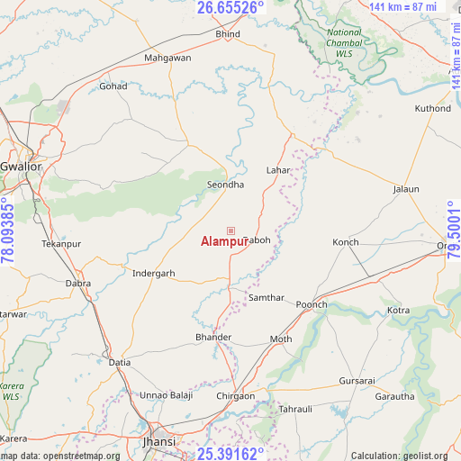
Alampur GPS coordinates[2]
26° 1' 30.504" North, 78° 47' 49.092" East
| Map corner | latitude | longitude |
|---|---|---|
| Upper-left | 26.65526°, | 78.09385° |
| Center: | 26.02514°, | 78.79697° |
| Lower-right: | 25.39162°, | 79.5001° |
| Map W x H: | 140.5×140.5 km | = 87.3×87.3mi |
| max Lat: | 34.9274° ⇑29.5% North |
| Alampur: | 26.02514° |
| min Lat: | ⇓70.5% South 8.09008° |
| min Long | Alampur | max Long |
| 68.82655° | 78.79697° | 96.81° |
| W 57%⇐ | ⇒43% E |
Elevation
Elevation of Alampur is 161 m = 528 ft, and this is 134.6 m = 442 ft below average elevation for this country.
| Max E: |
3681 m = 12077 ft | 57.4% |
| Avg. | 295.6 m = 970 ft | |
| Alampur | 161 m = 528 ft | |
Min E: |
1 m = 3 ft | 42.6% |
See also: India elevation on elevation.city.
Geographical zone
Alampur is located in North temperate zone (between Tropic of Cancer and the Arctic Circle). Distance of this Northern Tropic circle is 287.8 km =178.8 mi to South.| Distance of | km | miles | from Alampur |
|---|---|---|---|
| North Pole | 7113.3 | 4420 | to North |
| Arctic Circle | 4507.4 | 2800.8 | to North |
| Tropic Cancer | 287.8 | 178.8 | to South |
| Equator | 2893.7 | 1798.1 | to South |


Nearby cities:
15 places around Alampur: (largest is in red/bold)
• Bhānder
32.6 km =20.3 mi,  189°
189°
• Chirgaon
50.4 km =31.3 mi,  178°
178°
• Daboh
8.3 km =5.2 mi,  107°
107°
• Dabra
49 km =30.4 mi,  251°
251°
• Datia
51.7 km =32.1 mi,  220°
220°
• Konch
35.6 km =22.1 mi,  95°
95°
• Lahār
23.7 km =14.7 mi,  37°
37°
• Mau
29.6 km =18.4 mi,  334°
334°
• Mihona
34.1 km =21.2 mi,  32°
32°
• Moth
36.6 km =22.7 mi,  155°
155°
• Mādhogarh
47.7 km =29.6 mi,  54°
54°
• Nadīgaon
24.4 km =15.2 mi,  67°
67°
• Samthar
23 km =14.3 mi,  151°
151°
• Seondha
14.4 km =8.9 mi,  353°
353°
• Tekanpur
51.5 km =32 mi,  266°
266°
Sources, notices
• [Note1] Compared only with cities in India existing in our database
• [Src1] Map data: © OpenStreetMap contributors (CC-BY-SA)
• [Src2] Other city data from geonames.org with taken over terms of usage.
• [Src3] Geographical zone / Annual Mean Temperature by Robert A. Rohde @ Wikipedia
