Morena geodata
Morena (Madhya Pradesh) is a populated place; located in India in Asia/Kolkata (GMT+5.5) time zone. With population of 152,004 people, there are 290 cities with bigger population in this country. Compared to other cities in India, 74.7% of cities are located further ↓South; 51.4% of cities are located further →East and 53.8% of cities have higher elevation than Morena. Note1


Morena GPS coordinates[2]
26° 29' 56.112" North, 77° 59' 43.224" East
| Map corner | latitude | longitude |
|---|---|---|
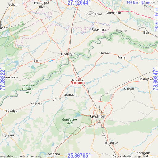
| Upper-left | 27.12644°, | 77.29222° |
| Center: | 26.49892°, | 77.99534° |
| Lower-right: | 25.86795°, | 78.69847° |
| Map W x H: | 139.9×139.9 km | = 86.9×86.9mi |
| max Lat: | 34.9274° ⇑25.3% North |
| Morena: | 26.49892° |
| min Lat: | ⇓74.7% South 8.09008° |
| min Long | Morena | max Long |
| 68.82655° | 77.99534° | 96.81° |
| W 48.6%⇐ | ⇒51.4% E |
Elevation
Elevation of Morena is 181 m = 594 ft, and this is 114.6 m = 376 ft below average elevation for this country.
| Max E: |
3681 m = 12077 ft | 53.8% |
| Avg. | 295.6 m = 970 ft | |
| Morena | 181 m = 594 ft | |
Min E: |
1 m = 3 ft | 46.2% |
See also: Morena elevation on elevation.city.
Geographical zone
Morena is located in North temperate zone (between Tropic of Cancer and the Arctic Circle). Distance of this Northern Tropic circle is 340.5 km =211.6 mi to South.| Distance of | km | miles | from Morena |
|---|---|---|---|
| North Pole | 7060.7 | 4387.3 | to North |
| Arctic Circle | 4454.8 | 2768.1 | to North |
| Tropic Cancer | 340.5 | 211.6 | to South |
| Equator | 2946.4 | 1830.8 | to South |


Nearby cities:
15 places around Morena: (largest is in red/bold)
• Ambāh
32.4 km =20.1 mi,  45°
45°
• Antri
53.5 km =33.2 mi,  156°
156°
• Bāri
41.1 km =25.5 mi,  293°
293°
• Dhaulpur
24.4 km =15.2 mi,  331°
331°
• Gohadi
45.1 km =28 mi,  99°
99°
• Gwalior
34.8 km =21.6 mi,  149°
149°
• Jagnair
56.3 km =35 mi,  316°
316°
• Jora
25.4 km =15.8 mi,  226°
226°
• Kailāras
43.5 km =27 mi,  240°
240°
• Khairāgarh
52.4 km =32.6 mi,  340°
340°
• Morār
38 km =23.6 mi,  142°
142°
• Pināhat
57.2 km =35.5 mi,  41°
41°
• Porsa
42.1 km =26.2 mi,  62°
62°
• Rājākhera
47.7 km =29.6 mi,  21°
21°
• Shamsābād
59 km =36.7 mi,  12°
12°
Sources, notices
• [Note1] Compared only with cities in India existing in our database
• [Src1] Map data: © OpenStreetMap contributors (CC-BY-SA)
• [Src2] Other city data from geonames.org with taken over terms of usage.
• [Src3] Geographical zone / Annual Mean Temperature by Robert A. Rohde @ Wikipedia
