Porsa geodata
Porsa (Madhya Pradesh) is a populated place; located in India in Asia/Kolkata (GMT+5.5) time zone. With population of 37,824 people, there are 1166 cities with bigger population in this country. Compared to other cities in India, 75.8% of cities are located further ↓South; 52.8% of cities are located further ←West and 56% of cities have higher elevation than Porsa. Note1


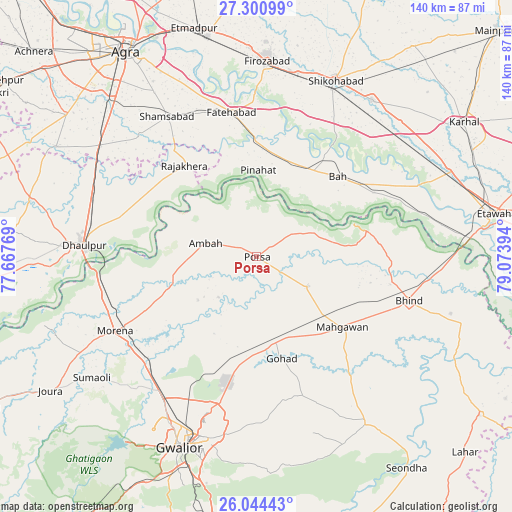
Porsa GPS coordinates[2]
26° 40' 27.984" North, 78° 22' 14.916" East
| Map corner | latitude | longitude |
|---|---|---|
| Upper-left | 27.30099°, | 77.66769° |
| Center: | 26.67444°, | 78.37081° |
| Lower-right: | 26.04443°, | 79.07394° |
| Map W x H: | 139.7×139.7 km | = 86.8×86.8mi |
| max Lat: | 34.9274° ⇑24.2% North |
| Porsa: | 26.67444° |
| min Lat: | ⇓75.8% South 8.09008° |
| min Long | Porsa | max Long |
| 68.82655° | 78.37081° | 96.81° |
| W 52.8%⇐ | ⇒47.2% E |
Elevation
Elevation of Porsa is 170 m = 558 ft, and this is 125.6 m = 412 ft below average elevation for this country.
| Max E: |
3681 m = 12077 ft | 56% |
| Avg. | 295.6 m = 970 ft | |
| Porsa | 170 m = 558 ft | |
Min E: |
1 m = 3 ft | 44% |
See also: India elevation on elevation.city.
Geographical zone
Porsa is located in North temperate zone (between Tropic of Cancer and the Arctic Circle). Distance of this Northern Tropic circle is 360 km =223.7 mi to South.| Distance of | km | miles | from Porsa |
|---|---|---|---|
| North Pole | 7041.1 | 4375.1 | to North |
| Arctic Circle | 4435.3 | 2756 | to North |
| Tropic Cancer | 360 | 223.7 | to South |
| Equator | 2965.9 | 1842.9 | to South |


Nearby cities:
15 places around Porsa: (largest is in red/bold)
• Ambāh
14.7 km =9.1 mi,  283°
283°
• Bhind
43.1 km =26.8 mi,  106°
106°
• Bāh
31 km =19.3 mi,  45°
45°
• Dhaulpur
48.8 km =30.3 mi,  272°
272°
• Fatehābād
39.7 km =24.7 mi,  350°
350°
• Fīrozābād
53 km =32.9 mi,  2°
2°
• Gohadi
27.8 km =17.3 mi,  165°
165°
• Mahgawān
31.5 km =19.6 mi,  129°
129°
• Morena
42.1 km =26.2 mi,  242°
242°
• Morār
51.9 km =32.2 mi,  196°
196°
• Pināhat
23.4 km =14.5 mi, 1°
• Rājākhera
31.8 km =19.8 mi,  321°
321°
• Shamsābād
45.3 km =28.1 mi,  327°
327°
• Shikohābād
52.7 km =32.7 mi,  23°
23°
• Sirsāganj
52.8 km =32.8 mi,  36°
36°
Sources, notices
• [Note1] Compared only with cities in India existing in our database
• [Src1] Map data: © OpenStreetMap contributors (CC-BY-SA)
• [Src2] Other city data from geonames.org with taken over terms of usage.
• [Src3] Geographical zone / Annual Mean Temperature by Robert A. Rohde @ Wikipedia
