Ambāh geodata
Ambāh (Madhya Pradesh) is a populated place; located in India in Asia/Kolkata (GMT+5.5) time zone. With population of 40,523 people, there are 1087 cities with bigger population in this country. Compared to other cities in India, 76.1% of cities are located further ↓South; 51.5% of cities are located further ←West and 54.8% of cities have higher elevation than Ambāh. Note1


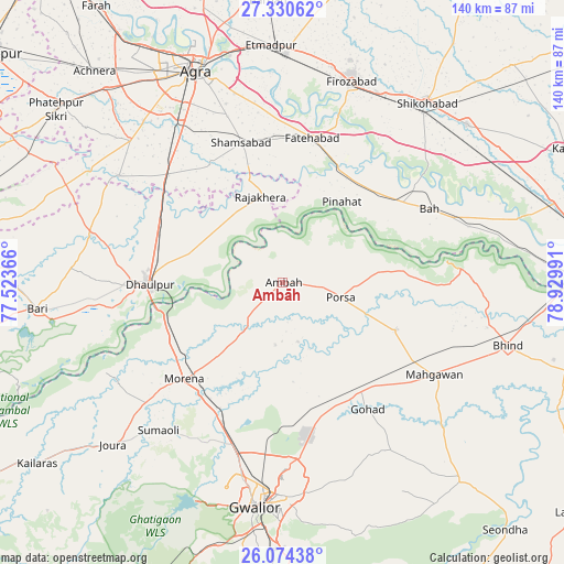
Ambāh GPS coordinates[2]
26° 42' 15.228" North, 78° 13' 36.408" East
| Map corner | latitude | longitude |
|---|---|---|
| Upper-left | 27.33062°, | 77.52366° |
| Center: | 26.70423°, | 78.22678° |
| Lower-right: | 26.07438°, | 78.92991° |
| Map W x H: | 139.7×139.7 km | = 86.8×86.8mi |
| max Lat: | 34.9274° ⇑23.9% North |
| Ambāh: | 26.70423° |
| min Lat: | ⇓76.1% South 8.09008° |
| min Long | Ambāh | max Long |
| 68.82655° | 78.22678° | 96.81° |
| W 51.5%⇐ | ⇒48.5% E |
Elevation
Elevation of Ambāh is 176 m = 577 ft, and this is 119.6 m = 392 ft below average elevation for this country.
| Max E: |
3681 m = 12077 ft | 54.8% |
| Avg. | 295.6 m = 970 ft | |
| Ambāh | 176 m = 577 ft | |
Min E: |
1 m = 3 ft | 45.2% |
See also: Ambāh elevation on elevation.city.
Geographical zone
Ambāh is located in North temperate zone (between Tropic of Cancer and the Arctic Circle). Distance of this Northern Tropic circle is 363.3 km =225.7 mi to South.| Distance of | km | miles | from Ambāh |
|---|---|---|---|
| North Pole | 7037.8 | 4373.1 | to North |
| Arctic Circle | 4431.9 | 2753.9 | to North |
| Tropic Cancer | 363.3 | 225.7 | to South |
| Equator | 2969.2 | 1845 | to South |


Nearby cities:
15 places around Ambāh: (largest is in red/bold)
• Bāh
40.8 km =25.4 mi,  63°
63°
• Dhaulpur
34.5 km =21.4 mi,  267°
267°
• Fatehābād
36.6 km =22.7 mi,  11°
11°
• Fīrozābād
52.5 km =32.6 mi,  18°
18°
• Gohadi
37 km =23 mi,  144°
144°
• Gwalior
53 km =32.9 mi,  185°
185°
• Khairāgarh
48.4 km =30.1 mi,  303°
303°
• Mahgawān
45.2 km =28.1 mi,  121°
121°
• Morena
32.4 km =20.1 mi,  225°
225°
• Morār
53.1 km =33 mi,  180°
180°
• Pināhat
25 km =15.5 mi,  36°
36°
• Porsa
14.7 km =9.1 mi,  103°
103°
• Rājākhera
22.2 km =13.8 mi,  345°
345°
• Shamsābād
36.3 km =22.6 mi,  343°
343°
• Tūndla
56.8 km =35.3 mi,  1°
1°
Sources, notices
• [Note1] Compared only with cities in India existing in our database
• [Src1] Map data: © OpenStreetMap contributors (CC-BY-SA)
• [Src2] Other city data from geonames.org with taken over terms of usage.
• [Src3] Geographical zone / Annual Mean Temperature by Robert A. Rohde @ Wikipedia
