Jagnair geodata
Jagnair (Uttar Pradesh) is a populated place; located in India in Asia/Kolkata (GMT+5.5) time zone. With population of 10,023 people, there are 2937 cities with bigger population in this country. Compared to other cities in India, 77.3% of cities are located further ↓South; 56.1% of cities are located further →East and 52.7% of cities have higher elevation than Jagnair. Note1


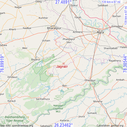
Jagnair GPS coordinates[2]
26° 51' 48.96" North, 77° 36' 8.316" East
| Map corner | latitude | longitude |
|---|---|---|
| Upper-left | 27.4891°, | 76.89919° |
| Center: | 26.8636°, | 77.60231° |
| Lower-right: | 26.23462°, | 78.30544° |
| Map W x H: | 139.5×139.5 km | = 86.7×86.7mi |
| max Lat: | 34.9274° ⇑22.7% North |
| Jagnair: | 26.8636° |
| min Lat: | ⇓77.3% South 8.09008° |
| min Long | Jagnair | max Long |
| 68.82655° | 77.60231° | 96.81° |
| W 43.9%⇐ | ⇒56.1% E |
Elevation
Elevation of Jagnair is 186 m = 610 ft, and this is 109.6 m = 360 ft below average elevation for this country.
| Max E: |
3681 m = 12077 ft | 52.7% |
| Avg. | 295.6 m = 970 ft | |
| Jagnair | 186 m = 610 ft | |
Min E: |
1 m = 3 ft | 47.3% |
See also: India elevation on elevation.city.
Geographical zone
Jagnair is located in North temperate zone (between Tropic of Cancer and the Arctic Circle). Distance of this Northern Tropic circle is 381 km =236.7 mi to South.| Distance of | km | miles | from Jagnair |
|---|---|---|---|
| North Pole | 7020.1 | 4362.1 | to North |
| Arctic Circle | 4414.2 | 2742.9 | to North |
| Tropic Cancer | 381 | 236.7 | to South |
| Equator | 2987 | 1856 | to South |


Nearby cities:
15 places around Jagnair: (largest is in red/bold)
• Achhnera
38.2 km =23.7 mi,  23°
23°
• Agra
54.3 km =33.7 mi,  49°
49°
• Bayāna
31.4 km =19.5 mi,  279°
279°
• Bharatpur
40.9 km =25.4 mi,  344°
344°
• Bāri
24.2 km =15 mi,  176°
176°
• Dhaulpur
33.4 km =20.8 mi,  124°
124°
• Farah
53.2 km =33.1 mi, 17°
• Fatehpur Sīkri
26.2 km =16.3 mi,  12°
12°
• Khairāgarh
23.2 km =14.4 mi,  67°
67°
• Kiraoli
35.5 km =22.1 mi,  30°
30°
• Kūmher
55.3 km =34.4 mi, 335°
• Morena
56.3 km =35 mi,  136°
136°
• Rājākhera
56.5 km =35.1 mi,  86°
86°
• Shamsābād
54.4 km =33.8 mi, 71°
• Wer
45.6 km =28.3 mi,  292°
292°
Sources, notices
• [Note1] Compared only with cities in India existing in our database
• [Src1] Map data: © OpenStreetMap contributors (CC-BY-SA)
• [Src2] Other city data from geonames.org with taken over terms of usage.
• [Src3] Geographical zone / Annual Mean Temperature by Robert A. Rohde @ Wikipedia
