Gohadi geodata
Gohadi (Madhya Pradesh) is a populated place; located in India in Asia/Kolkata (GMT+5.5) time zone. With population of 51,635 people, there are 866 cities with bigger population in this country. Compared to other cities in India, 74% of cities are located further ↓South; 53.5% of cities are located further ←West and 58% of cities have higher elevation than Gohadi. Note1


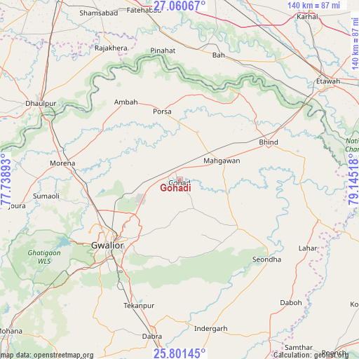
Gohadi GPS coordinates[2]
26° 25' 58.008" North, 78° 26' 31.38" East
| Map corner | latitude | longitude |
|---|---|---|
| Upper-left | 27.06067°, | 77.73893° |
| Center: | 26.43278°, | 78.44205° |
| Lower-right: | 25.80145°, | 79.14518° |
| Map W x H: | 140×140 km | = 87×87mi |
| max Lat: | 34.9274° ⇑26% North |
| Gohadi: | 26.43278° |
| min Lat: | ⇓74% South 8.09008° |
| min Long | Gohadi | max Long |
| 68.82655° | 78.44205° | 96.81° |
| W 53.5%⇐ | ⇒46.5% E |
Elevation
Elevation of Gohadi is 158 m = 518 ft, and this is 137.6 m = 451 ft below average elevation for this country.
| Max E: |
3681 m = 12077 ft | 58% |
| Avg. | 295.6 m = 970 ft | |
| Gohadi | 158 m = 518 ft | |
Min E: |
1 m = 3 ft | 42% |
See also: Gohadi elevation on elevation.city.
Geographical zone
Gohadi is located in North temperate zone (between Tropic of Cancer and the Arctic Circle). Distance of this Northern Tropic circle is 333.1 km =207 mi to South.| Distance of | km | miles | from Gohadi |
|---|---|---|---|
| North Pole | 7068 | 4391.9 | to North |
| Arctic Circle | 4462.1 | 2772.6 | to North |
| Tropic Cancer | 333.1 | 207 | to South |
| Equator | 2939 | 1826.2 | to South |


Nearby cities:
15 places around Gohadi: (largest is in red/bold)
• Ambāh
37 km =23 mi,  324°
324°
• Antri
47.6 km =29.6 mi,  209°
209°
• Bhind
37.4 km =23.2 mi,  66°
66°
• Bāh
50.8 km =31.6 mi,  17°
17°
• Gwalior
35 km =21.7 mi,  229°
229°
• Mahgawān
18.6 km =11.6 mi, 68°
• Mau
29.4 km =18.3 mi,  129°
129°
• Mihona
56.1 km =34.9 mi,  107°
107°
• Morena
45.1 km =28 mi,  279°
279°
• Morār
31.5 km =19.6 mi,  223°
223°
• Pināhat
50.7 km =31.5 mi,  352°
352°
• Porsa
27.8 km =17.3 mi, 345°
• Seondha
45.9 km =28.5 mi, 132°
• Tekanpur
51.3 km =31.9 mi,  197°
197°
• Umri
50 km =31.1 mi,  80°
80°
Sources, notices
• [Note1] Compared only with cities in India existing in our database
• [Src1] Map data: © OpenStreetMap contributors (CC-BY-SA)
• [Src2] Other city data from geonames.org with taken over terms of usage.
• [Src3] Geographical zone / Annual Mean Temperature by Robert A. Rohde @ Wikipedia
