Bāri geodata
Bāri (Rajasthan) is a populated place; located in India in Asia/Kolkata (GMT+5.5) time zone. With population of 56,136 people, there are 791 cities with bigger population in this country. Compared to other cities in India, 75.7% of cities are located further ↓South; 55.8% of cities are located further →East and 51.4% of cities have lower elevation than Bāri. Note1


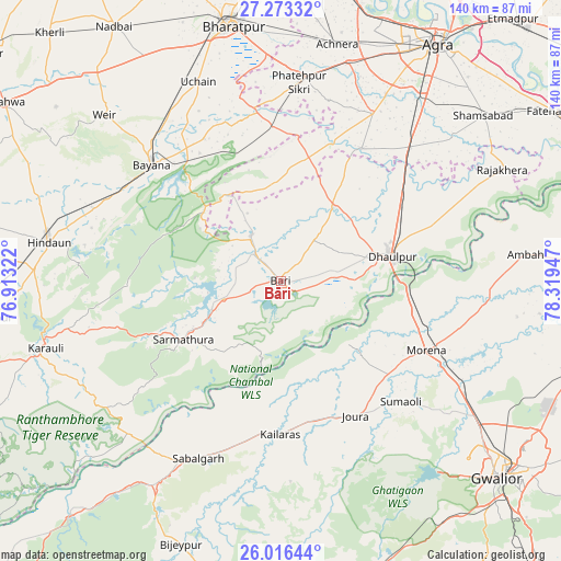
Bāri GPS coordinates[2]
26° 38' 47.796" North, 77° 36' 58.824" East
| Map corner | latitude | longitude |
|---|---|---|
| Upper-left | 27.27332°, | 76.91322° |
| Center: | 26.64661°, | 77.61634° |
| Lower-right: | 26.01644°, | 78.31947° |
| Map W x H: | 139.8×139.8 km | = 86.9×86.9mi |
| max Lat: | 34.9274° ⇑24.3% North |
| Bāri: | 26.64661° |
| min Lat: | ⇓75.7% South 8.09008° |
| min Long | Bāri | max Long |
| 68.82655° | 77.61634° | 96.81° |
| W 44.2%⇐ | ⇒55.8% E |
Elevation
Elevation of Bāri is 210 m = 689 ft, and this is 85.6 m = 281 ft below average elevation for this country.
| Max E: |
3681 m = 12077 ft | 48.6% |
| Avg. | 295.6 m = 970 ft | |
| Bāri | 210 m = 689 ft | |
Min E: |
1 m = 3 ft | 51.4% |
See also: Bāri elevation on elevation.city.
Geographical zone
Bāri is located in North temperate zone (between Tropic of Cancer and the Arctic Circle). Distance of this Northern Tropic circle is 356.9 km =221.8 mi to South.| Distance of | km | miles | from Bāri |
|---|---|---|---|
| North Pole | 7044.2 | 4377.1 | to North |
| Arctic Circle | 4438.3 | 2757.8 | to North |
| Tropic Cancer | 356.9 | 221.8 | to South |
| Equator | 2962.8 | 1841 | to South |


Nearby cities:
15 places around Bāri: (largest is in red/bold)
• Achhnera
60.7 km =37.7 mi,  13°
13°
• Ambāh
61 km =37.9 mi,  83°
83°
• Bayāna
43.5 km =27 mi,  311°
311°
• Dhaulpur
26.7 km =16.6 mi, 78°
• Fatehpur Sīkri
49.9 km =31 mi,  4°
4°
• Hindaun
58.5 km =36.4 mi,  279°
279°
• Jagnair
24.2 km =15 mi,  356°
356°
• Jora
38.9 km =24.2 mi,  150°
150°
• Kailāras
38 km =23.6 mi,  180°
180°
• Karauli
60.8 km =37.8 mi,  254°
254°
• Khairāgarh
38.6 km =24 mi,  31°
31°
• Kiraoli
57.1 km =35.5 mi,  17°
17°
• Morena
41.1 km =25.5 mi,  113°
113°
• Sabalgarh
48.8 km =30.3 mi,  205°
205°
• Wer
60.1 km =37.3 mi, 313°
Sources, notices
• [Note1] Compared only with cities in India existing in our database
• [Src1] Map data: © OpenStreetMap contributors (CC-BY-SA)
• [Src2] Other city data from geonames.org with taken over terms of usage.
• [Src3] Geographical zone / Annual Mean Temperature by Robert A. Rohde @ Wikipedia
