Jora geodata
Jora (Madhya Pradesh) is a populated place; located in India in Asia/Kolkata (GMT+5.5) time zone. With population of 26,338 people, there are 1618 cities with bigger population in this country. Compared to other cities in India, 73.4% of cities are located further ↓South; 53.5% of cities are located further →East and 51.9% of cities have higher elevation than Jora. Note1


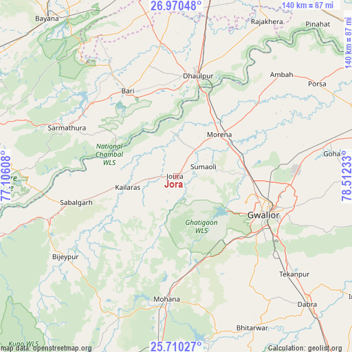
Jora GPS coordinates[2]
26° 20' 31.524" North, 77° 48' 33.12" East
| Map corner | latitude | longitude |
|---|---|---|
| Upper-left | 26.97048°, | 77.10608° |
| Center: | 26.34209°, | 77.8092° |
| Lower-right: | 25.71027°, | 78.51233° |
| Map W x H: | 140.1×140.1 km | = 87.1×87.1mi |
| max Lat: | 34.9274° ⇑26.6% North |
| Jora: | 26.34209° |
| min Lat: | ⇓73.4% South 8.09008° |
| min Long | Jora | max Long |
| 68.82655° | 77.8092° | 96.81° |
| W 46.5%⇐ | ⇒53.5% E |
Elevation
Elevation of Jora is 191 m = 627 ft, and this is 104.6 m = 343 ft below average elevation for this country.
| Max E: |
3681 m = 12077 ft | 51.9% |
| Avg. | 295.6 m = 970 ft | |
| Jora | 191 m = 627 ft | |
Min E: |
1 m = 3 ft | 48.1% |
See also: India elevation on elevation.city.
Geographical zone
Jora is located in North temperate zone (between Tropic of Cancer and the Arctic Circle). Distance of this Northern Tropic circle is 323 km =200.7 mi to South.| Distance of | km | miles | from Jora |
|---|---|---|---|
| North Pole | 7078.1 | 4398.1 | to North |
| Arctic Circle | 4472.2 | 2778.9 | to North |
| Tropic Cancer | 323 | 200.7 | to South |
| Equator | 2929 | 1820 | to South |


Nearby cities:
15 places around Jora: (largest is in red/bold)
• Ambāh
57.9 km =36 mi,  45°
45°
• Antri
51 km =31.7 mi,  128°
128°
• Bhitarwār
68.2 km =42.4 mi,  153°
153°
• Bāri
38.9 km =24.2 mi,  330°
330°
• Dhaulpur
39.6 km =24.6 mi,  10°
10°
• Gohadi
63.8 km =39.6 mi,  80°
80°
• Gwalior
38.4 km =23.9 mi,  108°
108°
• Jagnair
61.5 km =38.2 mi,  340°
340°
• Kailāras
19.7 km =12.2 mi,  257°
257°
• Khairāgarh
66.8 km =41.5 mi,  0°
0°
• Morena
25.4 km =15.8 mi, 46°
• Morār
43.4 km =27 mi, 107°
• Porsa
67 km =41.6 mi,  56°
56°
• Sabalgarh
41.3 km =25.7 mi, 255°
• Tekanpur
61.1 km =38 mi, 129°
Sources, notices
• [Note1] Compared only with cities in India existing in our database
• [Src1] Map data: © OpenStreetMap contributors (CC-BY-SA)
• [Src2] Other city data from geonames.org with taken over terms of usage.
• [Src3] Geographical zone / Annual Mean Temperature by Robert A. Rohde @ Wikipedia
