Kherālu geodata
Kherālu (Gujarat) is a populated place; located in India in Asia/Kolkata (GMT+5.5) time zone. With population of 20,755 people, there are 1987 cities with bigger population in this country. Compared to other cities in India, 57.5% of cities are located further ↓South; 96.6% of cities are located further →East and 54.3% of cities have higher elevation than Kherālu. Note1


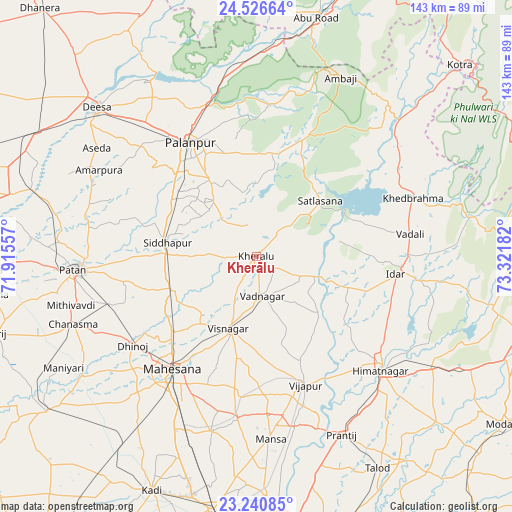
Kherālu GPS coordinates[2]
23° 53' 7.224" North, 72° 37' 7.284" East
| Map corner | latitude | longitude |
|---|---|---|
| Upper-left | 24.52664°, | 71.91557° |
| Center: | 23.88534°, | 72.61869° |
| Lower-right: | 23.24085°, | 73.32182° |
| Map W x H: | 143×143 km | = 88.9×88.9mi |
| max Lat: | 34.9274° ⇑42.5% North |
| Kherālu: | 23.88534° |
| min Lat: | ⇓57.5% South 8.09008° |
| min Long | Kherālu | max Long |
| 68.82655° | 72.61869° | 96.81° |
| W 3.4%⇐ | ⇒96.6% E |
Elevation
Elevation of Kherālu is 179 m = 587 ft, and this is 116.6 m = 383 ft below average elevation for this country.
| Max E: |
3681 m = 12077 ft | 54.3% |
| Avg. | 295.6 m = 970 ft | |
| Kherālu | 179 m = 587 ft | |
Min E: |
1 m = 3 ft | 45.7% |
See also: India elevation on elevation.city.
Geographical zone
Kherālu is located in North temperate zone (between Tropic of Cancer and the Arctic Circle). Distance of this Northern Tropic circle is 49.9 km =31 mi to South.| Distance of | km | miles | from Kherālu |
|---|---|---|---|
| North Pole | 7351.3 | 4567.9 | to North |
| Arctic Circle | 4745.4 | 2948.7 | to North |
| Tropic Cancer | 49.9 | 31 | to South |
| Equator | 2655.8 | 1650.2 | to South |


Nearby cities:
15 places around Kherālu: (largest is in red/bold)
• Chhala
66.1 km =41.1 mi,  166°
166°
• Chānasma
54.9 km =34.1 mi,  249°
249°
• Dīsa
60.7 km =37.7 mi,  312°
312°
• Himatnagar
47.6 km =29.6 mi,  132°
132°
• Jhulasan
63.7 km =39.6 mi,  193°
193°
• Khedbrahma
46.3 km =28.8 mi,  69°
69°
• Kānodar
32.2 km =20 mi, 314°
• Mānsa
51.3 km =31.9 mi,  175°
175°
• Pālanpur
36.7 km =22.8 mi,  330°
330°
• Pātan
49.9 km =31 mi,  265°
265°
• Siddhapur
25.3 km =15.7 mi,  278°
278°
• Unjha
24.9 km =15.5 mi, 248°
• Vadnagar
11.2 km =7 mi, 169°
• Vijāpur
38.3 km =23.8 mi,  159°
159°
• Visnagar
21.8 km =13.5 mi,  198°
198°
Sources, notices
• [Note1] Compared only with cities in India existing in our database
• [Src1] Map data: © OpenStreetMap contributors (CC-BY-SA)
• [Src2] Other city data from geonames.org with taken over terms of usage.
• [Src3] Geographical zone / Annual Mean Temperature by Robert A. Rohde @ Wikipedia
