Unjha geodata
Unjha (Gujarat) is a populated place; located in India in Asia/Kolkata (GMT+5.5) time zone. With population of 54,620 people, there are 814 cities with bigger population in this country. Compared to other cities in India, 56.9% of cities are located further ↓South; 97% of cities are located further →East and 65.6% of cities have higher elevation than Unjha. Note1


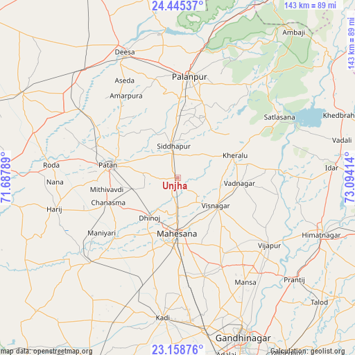
Unjha GPS coordinates[2]
23° 48' 13.176" North, 72° 23' 27.636" East
| Map corner | latitude | longitude |
|---|---|---|
| Upper-left | 24.44537°, | 71.68789° |
| Center: | 23.80366°, | 72.39101° |
| Lower-right: | 23.15876°, | 73.09414° |
| Map W x H: | 143.1×143.1 km | = 88.9×88.9mi |
| max Lat: | 34.9274° ⇑43.1% North |
| Unjha: | 23.80366° |
| min Lat: | ⇓56.9% South 8.09008° |
| min Long | Unjha | max Long |
| 68.82655° | 72.39101° | 96.81° |
| W 3%⇐ | ⇒97% E |
Elevation
Elevation of Unjha is 116 m = 381 ft, and this is 179.6 m = 589 ft below average elevation for this country.
| Max E: |
3681 m = 12077 ft | 65.6% |
| Avg. | 295.6 m = 970 ft | |
| Unjha | 116 m = 381 ft | |
Min E: |
1 m = 3 ft | 34.4% |
See also: Unjha elevation on elevation.city.
Geographical zone
Unjha is located in North temperate zone (between Tropic of Cancer and the Arctic Circle). Distance of this Northern Tropic circle is 40.8 km =25.4 mi to South.| Distance of | km | miles | from Unjha |
|---|---|---|---|
| North Pole | 7360.3 | 4573.5 | to North |
| Arctic Circle | 4754.5 | 2954.3 | to North |
| Tropic Cancer | 40.8 | 25.4 | to South |
| Equator | 2646.7 | 1644.6 | to South |


Nearby cities:
15 places around Unjha: (largest is in red/bold)
• Chānasma
30 km =18.6 mi,  250°
250°
• Dīsa
54.7 km =34 mi,  336°
336°
• Himatnagar
62.8 km =39 mi,  111°
111°
• Hārij
50.8 km =31.6 mi,  256°
256°
• Jhulasan
53.5 km =33.2 mi,  170°
170°
• Kadi
56.4 km =35 mi,  185°
185°
• Kherālu
24.9 km =15.5 mi,  68°
68°
• Kānodar
31.8 km =19.8 mi,  0°
0°
• Mānsa
50 km =31.1 mi,  147°
147°
• Pālanpur
41.2 km =25.6 mi,  6°
6°
• Pātan
27.1 km =16.8 mi,  281°
281°
• Siddhapur
12.8 km =8 mi,  351°
351°
• Vadnagar
25.3 km =15.7 mi,  94°
94°
• Vijāpur
45.2 km =28.1 mi,  126°
126°
• Visnagar
20.1 km =12.5 mi, 125°
Sources, notices
• [Note1] Compared only with cities in India existing in our database
• [Src1] Map data: © OpenStreetMap contributors (CC-BY-SA)
• [Src2] Other city data from geonames.org with taken over terms of usage.
• [Src3] Geographical zone / Annual Mean Temperature by Robert A. Rohde @ Wikipedia
