Manavālakurichi geodata
Manavālakurichi (Tamil Nadu) is a populated place; located in India in Asia/Kolkata (GMT+5.5) time zone. With population of 10,720 people, there are 2865 cities with bigger population in this country. Compared to other cities in India, 100% of cities are located further ↑North; 59.7% of cities are located further →East and 88.1% of cities have higher elevation than Manavālakurichi. Note1


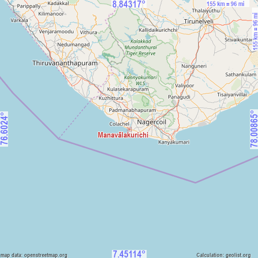
Manavālakurichi GPS coordinates[2]
8° 8' 51.936" North, 77° 18' 19.872" East
| Map corner | latitude | longitude |
|---|---|---|
| Upper-left | 8.84317°, | 76.6024° |
| Center: | 8.14776°, | 77.30552° |
| Lower-right: | 7.45114°, | 78.00865° |
| Map W x H: | 154.8×154.8 km | = 96.2×96.2mi |
| max Lat: | 34.9274° ⇑100% North |
| Manavālakurichi: | 8.14776° |
| min Lat: | ⇓0% South 8.09008° |
| min Long | Manavālakurich | max Long |
| 68.82655° | 77.30552° | 96.81° |
| W 40.3%⇐ | ⇒59.7% E |
Elevation
Elevation of Manavālakurichi is 22 m = 72 ft, and this is 273.6 m = 898 ft below average elevation for this country.
| Max E: |
3681 m = 12077 ft | 88.1% |
| Avg. | 295.6 m = 970 ft | |
| Manavālakurichi | 22 m = 72 ft | |
Min E: |
1 m = 3 ft | 11.9% |
See also: India elevation on elevation.city.
Geographical zone
Manavālakurichi is located in North Torrid zone (between Equator and Tropic of Cancer). Distance of Equator is 905.9 km =562.9 mi to South.| Distance of | km | miles | from Manavālakurichi |
|---|---|---|---|
| North Pole | 9101.1 | 5655.2 | to North |
| Arctic Circle | 6495.2 | 4035.9 | to North |
| Tropic Cancer | 1700 | 1056.3 | to North |
| Equator | 905.9 | 562.9 | to South |


Nearby cities:
15 places around Manavālakurichi: (largest is in red/bold)
• Colachel
6.3 km =3.9 mi,  304°
304°
• Eraniel
6.6 km =4.1 mi,  11°
11°
• Kalakkādu
48.8 km =30.3 mi,  33°
33°
• Kallidaikurichi
62.4 km =38.8 mi,  16°
16°
• Kanniyākumāri
26.4 km =16.4 mi,  104°
104°
• Kovalam
41.8 km =26 mi,  305°
305°
• Kuzhithurai
22.7 km =14.1 mi,  326°
326°
• Nanguneri
54.6 km =33.9 mi,  45°
45°
• Nedumangād
60.6 km =37.7 mi, 326°
• Neyyāttinkara
36.9 km =22.9 mi,  319°
319°
• Nāgercoil
14.4 km =8.9 mi,  76°
76°
• Padmanābhapuram
11 km =6.8 mi, 11°
• Suchindram
17.8 km =11.1 mi,  87°
87°
• Thiruvananthapuram
54.3 km =33.7 mi, 313°
• Vadakku Valliyūr
42.7 km =26.5 mi, 52°
Sources, notices
• [Note1] Compared only with cities in India existing in our database
• [Src1] Map data: © OpenStreetMap contributors (CC-BY-SA)
• [Src2] Other city data from geonames.org with taken over terms of usage.
• [Src3] Geographical zone / Annual Mean Temperature by Robert A. Rohde @ Wikipedia
