Thiruvananthapuram geodata
Thiruvananthapuram (Kerala) is a seat of a first-order administrative division; located in India in Asia/Kolkata (GMT+5.5) time zone. With population of 784,153 people, there are 57 cities with bigger population in this country. Compared to other cities in India, 99.6% of cities are located further ↑North; 63.7% of cities are located further →East and 89.9% of cities have higher elevation than Thiruvananthapuram. Note1


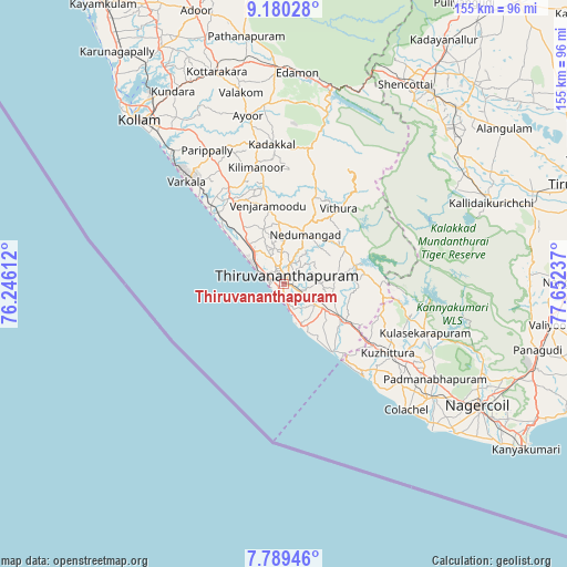
Thiruvananthapuram GPS coordinates[2]
8° 29' 7.8" North, 76° 56' 57.264" East
| Map corner | latitude | longitude |
|---|---|---|
| Upper-left | 9.18028°, | 76.24612° |
| Center: | 8.4855°, | 76.94924° |
| Lower-right: | 7.78946°, | 77.65237° |
| Map W x H: | 154.6×154.6 km | = 96.1×96.1mi |
| max Lat: | 34.9274° ⇑99.6% North |
| Thiruvananthapuram: | 8.4855° |
| min Lat: | ⇓0.4% South 8.09008° |
| min Long | Thiruvananthapu | max Long |
| 68.82655° | 76.94924° | 96.81° |
| W 36.3%⇐ | ⇒63.7% E |
Elevation
Elevation of Thiruvananthapuram is 18 m = 59 ft, and this is 277.6 m = 911 ft below average elevation for this country.
| Max E: |
3681 m = 12077 ft | 89.9% |
| Avg. | 295.6 m = 970 ft | |
| Thiruvananthapuram | 18 m = 59 ft | |
Min E: |
1 m = 3 ft | 10.1% |
See also: Thiruvananthapuram elevation on elevation.city.
Geographical zone
Thiruvananthapuram is located in North Torrid zone (between Equator and Tropic of Cancer). Distance of Equator is 943.5 km =586.3 mi to South.| Distance of | km | miles | from Thiruvananthapuram |
|---|---|---|---|
| North Pole | 9063.6 | 5631.9 | to North |
| Arctic Circle | 6457.7 | 4012.6 | to North |
| Tropic Cancer | 1662.4 | 1033 | to North |
| Equator | 943.5 | 586.3 | to South |


Nearby cities:
15 places around Thiruvananthapuram: (largest is in red/bold)
• Attingal
27.7 km =17.2 mi,  327°
327°
• Colachel
48.1 km =29.9 mi,  135°
135°
• Eraniel
51 km =31.7 mi,  127°
127°
• Kadakkavoor
29.4 km =18.3 mi,  317°
317°
• Kollam
59.5 km =37 mi, 317°
• Kovalam
14.2 km =8.8 mi,  158°
158°
• Kuzhithurai
32.6 km =20.3 mi,  124°
124°
• Manavālakurichi
54.3 km =33.7 mi, 133°
• Nedumangād
14.2 km =8.8 mi,  23°
23°
• Neyyāttinkara
17.9 km =11.1 mi, 122°
• Padmanābhapuram
49.3 km =30.6 mi, 122°
• Paravūr Tekkumbhāgam
46.2 km =28.7 mi, 318°
• Punalūr
59.5 km =37 mi,  357°
357°
• Varkala
37.6 km =23.4 mi, 317°
• Vettūr
35.6 km =22.1 mi, 316°
Sources, notices
• [Note1] Compared only with cities in India existing in our database
• [Src1] Map data: © OpenStreetMap contributors (CC-BY-SA)
• [Src2] Other city data from geonames.org with taken over terms of usage.
• [Src3] Geographical zone / Annual Mean Temperature by Robert A. Rohde @ Wikipedia
