Kovalam geodata
Kovalam (Kerala) is a populated place; located in India in Asia/Kolkata (GMT+5.5) time zone. With population of 6,000 people, there are 3290 cities with bigger population in this country. Compared to other cities in India, 99.7% of cities are located further ↑North; 63.2% of cities are located further →East and 85.1% of cities have higher elevation than Kovalam. Note1


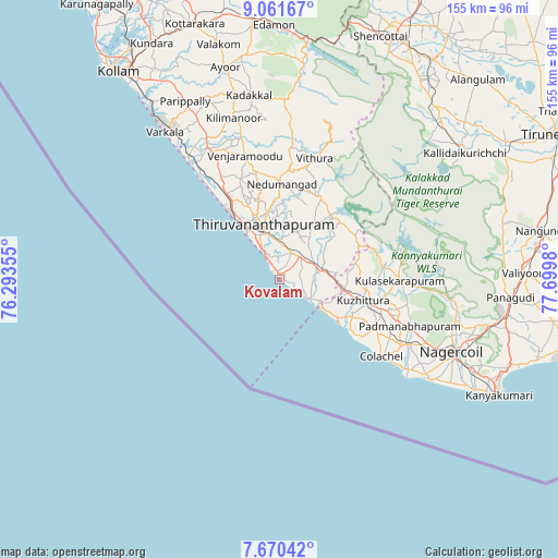
Kovalam GPS coordinates[2]
8° 22' 0.012" North, 76° 59' 48.012" East
| Map corner | latitude | longitude |
|---|---|---|
| Upper-left | 9.06167°, | 76.29355° |
| Center: | 8.36667°, | 76.99667° |
| Lower-right: | 7.67042°, | 77.6998° |
| Map W x H: | 154.7×154.7 km | = 96.1×96.1mi |
| max Lat: | 34.9274° ⇑99.7% North |
| Kovalam: | 8.36667° |
| min Lat: | ⇓0.3% South 8.09008° |
| min Long | Kovalam | max Long |
| 68.82655° | 76.99667° | 96.81° |
| W 36.8%⇐ | ⇒63.2% E |
Elevation
Elevation of Kovalam is 30 m = 98 ft, and this is 265.6 m = 871 ft below average elevation for this country.
| Max E: |
3681 m = 12077 ft | 85.1% |
| Avg. | 295.6 m = 970 ft | |
| Kovalam | 30 m = 98 ft | |
Min E: |
1 m = 3 ft | 14.9% |
See also: India elevation on elevation.city.
Geographical zone
Kovalam is located in North Torrid zone (between Equator and Tropic of Cancer). Distance of Equator is 930.3 km =578.1 mi to South.| Distance of | km | miles | from Kovalam |
|---|---|---|---|
| North Pole | 9076.8 | 5640.1 | to North |
| Arctic Circle | 6470.9 | 4020.8 | to North |
| Tropic Cancer | 1675.6 | 1041.2 | to North |
| Equator | 930.3 | 578.1 | to South |


Nearby cities:
15 places around Kovalam: (largest is in red/bold)
• Attingal
41.7 km =25.9 mi,  331°
331°
• Colachel
35.5 km =22.1 mi,  125°
125°
• Eraniel
39.5 km =24.5 mi,  116°
116°
• Kadakkavoor
42.9 km =26.7 mi,  324°
324°
• Kuzhithurai
22.2 km =13.8 mi,  104°
104°
• Manavālakurichi
41.8 km =26 mi, 125°
• Nedumangād
26.2 km =16.3 mi,  1°
1°
• Neyyāttinkara
10.4 km =6.5 mi,  70°
70°
• Nāgercoil
52.3 km =32.5 mi,  113°
113°
• Padmanābhapuram
38.7 km =24 mi, 110°
• Paravūr Tekkumbhāgam
59.8 km =37.2 mi, 322°
• Suchindram
56.9 km =35.4 mi, 114°
• Thiruvananthapuram
14.2 km =8.8 mi,  338°
338°
• Varkala
51.1 km =31.8 mi, 322°
• Vettūr
49.1 km =30.5 mi, 322°
Sources, notices
• [Note1] Compared only with cities in India existing in our database
• [Src1] Map data: © OpenStreetMap contributors (CC-BY-SA)
• [Src2] Other city data from geonames.org with taken over terms of usage.
• [Src3] Geographical zone / Annual Mean Temperature by Robert A. Rohde @ Wikipedia
