Bhawānīgarh geodata
Bhawānīgarh (Punjab) is a populated place; located in India in Asia/Kolkata (GMT+5.5) time zone. With population of 19,376 people, there are 2090 cities with bigger population in this country. Compared to other cities in India, 93.7% of cities are located further ↓South; 73.3% of cities are located further →East and 59.5% of cities have lower elevation than Bhawānīgarh. Note1


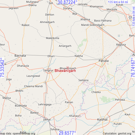
Bhawānīgarh GPS coordinates[2]
30° 16' 0.66" North, 76° 2' 18.744" East
| Map corner | latitude | longitude |
|---|---|---|
| Upper-left | 30.87224°, | 75.33542° |
| Center: | 30.26685°, | 76.03854° |
| Lower-right: | 29.6577°, | 76.74167° |
| Map W x H: | 135×135 km | = 83.9×83.9mi |
| max Lat: | 34.9274° ⇑6.3% North |
| Bhawānīgarh: | 30.26685° |
| min Lat: | ⇓93.7% South 8.09008° |
| min Long | Bhawānīgarh | max Long |
| 68.82655° | 76.03854° | 96.81° |
| W 26.7%⇐ | ⇒73.3% E |
Elevation
Elevation of Bhawānīgarh is 247 m = 810 ft, and this is 48.6 m = 159 ft below average elevation for this country.
| Max E: |
3681 m = 12077 ft | 40.5% |
| Avg. | 295.6 m = 970 ft | |
| Bhawānīgarh | 247 m = 810 ft | |
Min E: |
1 m = 3 ft | 59.5% |
See also: India elevation on elevation.city.
Geographical zone
Bhawānīgarh is located in North temperate zone (between Tropic of Cancer and the Arctic Circle). Distance of this Northern Tropic circle is 759.4 km =471.9 mi to South.| Distance of | km | miles | from Bhawānīgarh |
|---|---|---|---|
| North Pole | 6641.7 | 4127 | to North |
| Arctic Circle | 4035.8 | 2507.7 | to North |
| Tropic Cancer | 759.4 | 471.9 | to South |
| Equator | 3365.4 | 2091.2 | to South |


Nearby cities:
15 places around Bhawānīgarh: (largest is in red/bold)
• Akālgarh
51.6 km =32.1 mi,  195°
195°
• Amloh
42.3 km =26.3 mi,  26°
26°
• Barnāla
48.5 km =30.1 mi,  284°
284°
• Chīma
46.8 km =29.1 mi,  5°
5°
• Dhanaula
44.7 km =27.8 mi,  272°
272°
• Dhūri
19.9 km =12.4 mi,  304°
304°
• Dirba
22 km =13.7 mi,  190°
190°
• Khanna
51.8 km =32.2 mi,  19°
19°
• Laungowāl
35.3 km =21.9 mi,  256°
256°
• Māler Kotla
33.1 km =20.6 mi,  332°
332°
• Nābha
16.3 km =10.1 mi,  42°
42°
• Patiāla
34.8 km =21.6 mi,  77°
77°
• Sanaur
40.4 km =25.1 mi, 84°
• Sangrūr
18.8 km =11.7 mi, 262°
• Sunām
27.6 km =17.1 mi,  236°
236°
Sources, notices
• [Note1] Compared only with cities in India existing in our database
• [Src1] Map data: © OpenStreetMap contributors (CC-BY-SA)
• [Src2] Other city data from geonames.org with taken over terms of usage.
• [Src3] Geographical zone / Annual Mean Temperature by Robert A. Rohde @ Wikipedia
