Sangrūr geodata
Sangrūr (Punjab) is a populated place; located in India in Asia/Kolkata (GMT+5.5) time zone. With population of 88,615 people, there are 504 cities with bigger population in this country. Compared to other cities in India, 93.6% of cities are located further ↓South; 75.2% of cities are located further →East and 58.3% of cities have lower elevation than Sangrūr. Note1


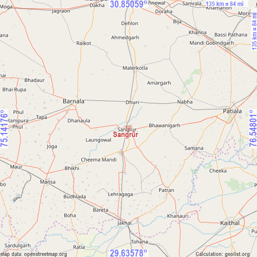
Sangrūr GPS coordinates[2]
30° 14' 42.216" North, 75° 50' 41.568" East
| Map corner | latitude | longitude |
|---|---|---|
| Upper-left | 30.85059°, | 75.14176° |
| Center: | 30.24506°, | 75.84488° |
| Lower-right: | 29.63578°, | 76.54801° |
| Map W x H: | 135.1×135.1 km | = 83.9×83.9mi |
| max Lat: | 34.9274° ⇑6.4% North |
| Sangrūr: | 30.24506° |
| min Lat: | ⇓93.6% South 8.09008° |
| min Long | Sangrūr | max Long |
| 68.82655° | 75.84488° | 96.81° |
| W 24.8%⇐ | ⇒75.2% E |
Elevation
Elevation of Sangrūr is 241 m = 791 ft, and this is 54.6 m = 179 ft below average elevation for this country.
| Max E: |
3681 m = 12077 ft | 41.7% |
| Avg. | 295.6 m = 970 ft | |
| Sangrūr | 241 m = 791 ft | |
Min E: |
1 m = 3 ft | 58.3% |
See also: Sangrūr elevation on elevation.city.
Geographical zone
Sangrūr is located in North temperate zone (between Tropic of Cancer and the Arctic Circle). Distance of this Northern Tropic circle is 757 km =470.4 mi to South.| Distance of | km | miles | from Sangrūr |
|---|---|---|---|
| North Pole | 6644.1 | 4128.5 | to North |
| Arctic Circle | 4038.2 | 2509.2 | to North |
| Tropic Cancer | 757 | 470.4 | to South |
| Equator | 3362.9 | 2089.6 | to South |


Nearby cities:
15 places around Sangrūr: (largest is in red/bold)
• Akālgarh
47.4 km =29.5 mi,  174°
174°
• Barnāla
31.9 km =19.8 mi,  296°
296°
• Bhawānīgarh
18.8 km =11.7 mi,  82°
82°
• Bhīkhi
36.3 km =22.6 mi,  235°
235°
• Budhlāda
44.5 km =27.7 mi,  217°
217°
• Dhanaula
26.4 km =16.4 mi,  278°
278°
• Dhūri
13.9 km =8.6 mi,  9°
9°
• Dirba
24.1 km =15 mi,  142°
142°
• Jākhal
49.9 km =31 mi,  182°
182°
• Laungowāl
16.8 km =10.4 mi,  250°
250°
• Māler Kotla
32 km =19.9 mi, 5°
• Mānsa
51.3 km =31.9 mi, 236°
• Nābha
32.9 km =20.4 mi,  63°
63°
• Rāikot
50.8 km =31.6 mi,  332°
332°
• Sunām
13.6 km =8.5 mi,  198°
198°
Sources, notices
• [Note1] Compared only with cities in India existing in our database
• [Src1] Map data: © OpenStreetMap contributors (CC-BY-SA)
• [Src2] Other city data from geonames.org with taken over terms of usage.
• [Src3] Geographical zone / Annual Mean Temperature by Robert A. Rohde @ Wikipedia
