Laungowāl geodata
Laungowāl (Punjab) is a populated place; located in India in Asia/Kolkata (GMT+5.5) time zone. With population of 21,880 people, there are 1908 cities with bigger population in this country. Compared to other cities in India, 93.4% of cities are located further ↓South; 76.7% of cities are located further →East and 57.1% of cities have lower elevation than Laungowāl. Note1


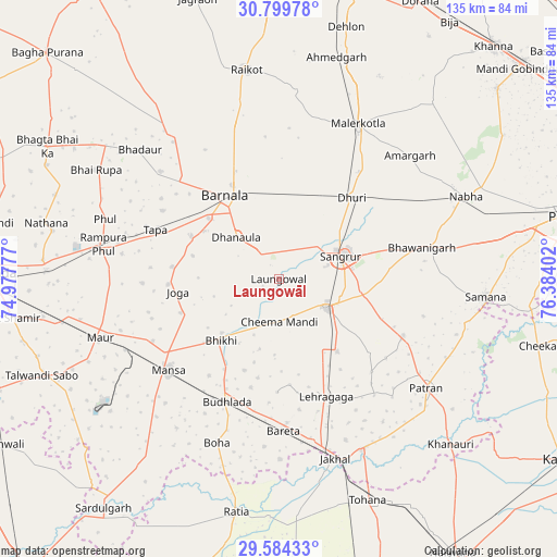
Laungowāl GPS coordinates[2]
30° 11' 38.148" North, 75° 40' 51.204" East
| Map corner | latitude | longitude |
|---|---|---|
| Upper-left | 30.79978°, | 74.97777° |
| Center: | 30.19393°, | 75.68089° |
| Lower-right: | 29.58433°, | 76.38402° |
| Map W x H: | 135.1×135.1 km | = 83.9×83.9mi |
| max Lat: | 34.9274° ⇑6.6% North |
| Laungowāl: | 30.19393° |
| min Lat: | ⇓93.4% South 8.09008° |
| min Long | Laungowāl | max Long |
| 68.82655° | 75.68089° | 96.81° |
| W 23.3%⇐ | ⇒76.7% E |
Elevation
Elevation of Laungowāl is 235 m = 771 ft, and this is 60.6 m = 199 ft below average elevation for this country.
| Max E: |
3681 m = 12077 ft | 42.9% |
| Avg. | 295.6 m = 970 ft | |
| Laungowāl | 235 m = 771 ft | |
Min E: |
1 m = 3 ft | 57.1% |
See also: India elevation on elevation.city.
Geographical zone
Laungowāl is located in North temperate zone (between Tropic of Cancer and the Arctic Circle). Distance of this Northern Tropic circle is 751.3 km =466.8 mi to South.| Distance of | km | miles | from Laungowāl |
|---|---|---|---|
| North Pole | 6649.8 | 4132 | to North |
| Arctic Circle | 4043.9 | 2512.8 | to North |
| Tropic Cancer | 751.3 | 466.8 | to South |
| Equator | 3357.3 | 2086.1 | to South |


Nearby cities:
15 places around Laungowāl: (largest is in red/bold)
• Akālgarh
46.2 km =28.7 mi,  154°
154°
• Barnāla
23.8 km =14.8 mi,  327°
327°
• Bhadaur
46 km =28.6 mi,  313°
313°
• Bhawānīgarh
35.3 km =21.9 mi,  76°
76°
• Bhīkhi
20.5 km =12.7 mi,  223°
223°
• Budhlāda
31.7 km =19.7 mi,  201°
201°
• Dhanaula
14.2 km =8.8 mi, 313°
• Dhūri
26.4 km =16.4 mi,  42°
42°
• Dirba
33.2 km =20.6 mi,  114°
114°
• Maur
43.2 km =26.8 mi,  253°
253°
• Māler Kotla
42 km =26.1 mi,  26°
26°
• Mānsa
35.3 km =21.9 mi,  229°
229°
• Rāmpura
42.8 km =26.6 mi,  279°
279°
• Sangrūr
16.8 km =10.4 mi,  70°
70°
• Sunām
13.5 km =8.4 mi,  122°
122°
Sources, notices
• [Note1] Compared only with cities in India existing in our database
• [Src1] Map data: © OpenStreetMap contributors (CC-BY-SA)
• [Src2] Other city data from geonames.org with taken over terms of usage.
• [Src3] Geographical zone / Annual Mean Temperature by Robert A. Rohde @ Wikipedia
