Barnāla geodata
Barnāla (Punjab) is a populated place; located in India in Asia/Kolkata (GMT+5.5) time zone. With population of 105,016 people, there are 416 cities with bigger population in this country. Compared to other cities in India, 94% of cities are located further ↓South; 78.1% of cities are located further →East and 57.4% of cities have lower elevation than Barnāla. Note1


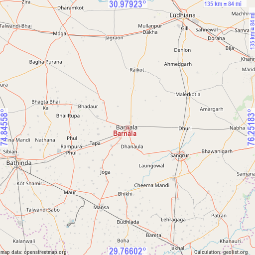
Barnāla GPS coordinates[2]
30° 22' 28.236" North, 75° 32' 55.32" East
| Map corner | latitude | longitude |
|---|---|---|
| Upper-left | 30.97923°, | 74.84558° |
| Center: | 30.37451°, | 75.5487° |
| Lower-right: | 29.76602°, | 76.25183° |
| Map W x H: | 134.9×134.9 km | = 83.8×83.8mi |
| max Lat: | 34.9274° ⇑6% North |
| Barnāla: | 30.37451° |
| min Lat: | ⇓94% South 8.09008° |
| min Long | Barnāla | max Long |
| 68.82655° | 75.5487° | 96.81° |
| W 21.9%⇐ | ⇒78.1% E |
Elevation
Elevation of Barnāla is 237 m = 778 ft, and this is 58.6 m = 192 ft below average elevation for this country.
| Max E: |
3681 m = 12077 ft | 42.6% |
| Avg. | 295.6 m = 970 ft | |
| Barnāla | 237 m = 778 ft | |
Min E: |
1 m = 3 ft | 57.4% |
See also: Barnāla elevation on elevation.city.
Geographical zone
Barnāla is located in North temperate zone (between Tropic of Cancer and the Arctic Circle). Distance of this Northern Tropic circle is 771.4 km =479.3 mi to South.| Distance of | km | miles | from Barnāla |
|---|---|---|---|
| North Pole | 6629.7 | 4119.5 | to North |
| Arctic Circle | 4023.8 | 2500.3 | to North |
| Tropic Cancer | 771.4 | 479.3 | to South |
| Equator | 3377.3 | 2098.6 | to South |


Nearby cities:
15 places around Barnāla: (largest is in red/bold)
• Badhni Kalān
42.1 km =26.2 mi,  324°
324°
• Bhadaur
23.8 km =14.8 mi,  298°
298°
• Bhawānīgarh
48.5 km =30.1 mi,  104°
104°
• Bhīkhi
35.1 km =21.8 mi,  182°
182°
• Dhanaula
10.5 km =6.5 mi,  166°
166°
• Dhūri
30.6 km =19 mi,  91°
91°
• Jagraon
46.5 km =28.9 mi,  351°
351°
• Laungowāl
23.8 km =14.8 mi,  147°
147°
• Maur
43.3 km =26.9 mi,  221°
221°
• Māler Kotla
36.2 km =22.5 mi,  61°
61°
• Mānsa
45.2 km =28.1 mi,  198°
198°
• Rāikot
31 km =19.3 mi,  9°
9°
• Rāmpura
32.3 km =20.1 mi,  245°
245°
• Sangrūr
31.9 km =19.8 mi,  116°
116°
• Sunām
36.4 km =22.6 mi,  138°
138°
Sources, notices
• [Note1] Compared only with cities in India existing in our database
• [Src1] Map data: © OpenStreetMap contributors (CC-BY-SA)
• [Src2] Other city data from geonames.org with taken over terms of usage.
• [Src3] Geographical zone / Annual Mean Temperature by Robert A. Rohde @ Wikipedia
