Madikeri geodata
Madikeri (Karnataka) is a populated place; located in India in Asia/Kolkata (GMT+5.5) time zone. With population of 33,540 people, there are 1294 cities with bigger population in this country. Compared to other cities in India, 88.7% of cities are located further ↑North; 76.4% of cities are located further →East and 96.7% of cities have lower elevation than Madikeri. Note1


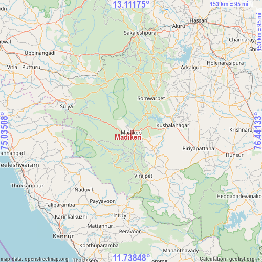
Madikeri GPS coordinates[2]
12° 25' 33.672" North, 75° 44' 17.52" East
| Map corner | latitude | longitude |
|---|---|---|
| Upper-left | 13.11175°, | 75.03508° |
| Center: | 12.42602°, | 75.7382° |
| Lower-right: | 11.73848°, | 76.44133° |
| Map W x H: | 152.7×152.7 km | = 94.9×94.9mi |
| max Lat: | 34.9274° ⇑88.7% North |
| Madikeri: | 12.42602° |
| min Lat: | ⇓11.3% South 8.09008° |
| min Long | Madikeri | max Long |
| 68.82655° | 75.7382° | 96.81° |
| W 23.6%⇐ | ⇒76.4% E |
Elevation
Elevation of Madikeri is 1141 m = 3743 ft, and this is 845.4 m = 2774 ft above average elevation for this country.
| Max E: |
3681 m = 12077 ft | 3.3% |
| Madikeri | 1141 m 3743 ft | |
| Avg. | 295.6 m = 970 ft | |
Min E: |
1 m = 3 ft | 96.7% |
See also: India elevation on elevation.city.
Geographical zone
Madikeri is located in North Torrid zone (between Equator and Tropic of Cancer). Distance of this Northern Tropic circle is 1224.3 km =760.7 mi to North.| Distance of | km | miles | from Madikeri |
|---|---|---|---|
| North Pole | 8625.4 | 5359.6 | to North |
| Arctic Circle | 6019.5 | 3740.3 | to North |
| Tropic Cancer | 1224.3 | 760.7 | to North |
| Equator | 1381.6 | 858.5 | to South |


Nearby cities:
15 places around Madikeri: (largest is in red/bold)
• Arkalgūd
51.1 km =31.8 mi,  43°
43°
• Gorūr
56.6 km =35.2 mi, 38°
• Kodlipet
44.7 km =27.8 mi,  21°
21°
• Konanūr
40.8 km =25.4 mi,  56°
56°
• Kushālnagar
24.2 km =15 mi,  81°
81°
• Mattanur
58 km =36 mi,  198°
198°
• Piriyāpatna
40.7 km =25.3 mi,  104°
104°
• Ponnampet
38.5 km =23.9 mi,  144°
144°
• Sakleshpur
57.5 km =35.7 mi,  5°
5°
• Sanivārsante
37.3 km =23.2 mi,  25°
25°
• Somvārpet
22.5 km =14 mi, 32°
• Sulya
40.9 km =25.4 mi,  291°
291°
• Suntikoppa
10.5 km =6.5 mi,  71°
71°
• Talipparamba
59.3 km =36.8 mi,  223°
223°
• Vīrarājendrapet
26.5 km =16.5 mi,  164°
164°
Sources, notices
• [Note1] Compared only with cities in India existing in our database
• [Src1] Map data: © OpenStreetMap contributors (CC-BY-SA)
• [Src2] Other city data from geonames.org with taken over terms of usage.
• [Src3] Geographical zone / Annual Mean Temperature by Robert A. Rohde @ Wikipedia
