Arkalgūd geodata
Arkalgūd (Karnataka) is a populated place; located in India in Asia/Kolkata (GMT+5.5) time zone. With population of 15,802 people, there are 2389 cities with bigger population in this country. Compared to other cities in India, 87.6% of cities are located further ↑North; 73% of cities are located further →East and 95.6% of cities have lower elevation than Arkalgūd. Note1


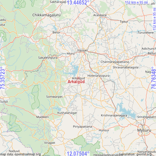
Arkalgūd GPS coordinates[2]
12° 45' 42.156" North, 76° 3' 37.26" East
| Map corner | latitude | longitude |
|---|---|---|
| Upper-left | 13.44652°, | 75.35723° |
| Center: | 12.76171°, | 76.06035° |
| Lower-right: | 12.07504°, | 76.76348° |
| Map W x H: | 152.5×152.5 km | = 94.8×94.8mi |
| max Lat: | 34.9274° ⇑87.6% North |
| Arkalgūd: | 12.76171° |
| min Lat: | ⇓12.4% South 8.09008° |
| min Long | Arkalgūd | max Long |
| 68.82655° | 76.06035° | 96.81° |
| W 27%⇐ | ⇒73% E |
Elevation
Elevation of Arkalgūd is 922 m = 3025 ft, and this is 626.4 m = 2055 ft above average elevation for this country.
| Max E: |
3681 m = 12077 ft | 4.4% |
| Arkalgūd | 922 m 3025 ft | |
| Avg. | 295.6 m = 970 ft | |
Min E: |
1 m = 3 ft | 95.6% |
See also: India elevation on elevation.city.
Geographical zone
Arkalgūd is located in North Torrid zone (between Equator and Tropic of Cancer). Distance of this Northern Tropic circle is 1186.9 km =737.5 mi to North.| Distance of | km | miles | from Arkalgūd |
|---|---|---|---|
| North Pole | 8588.1 | 5336.4 | to North |
| Arctic Circle | 5982.2 | 3717.2 | to North |
| Tropic Cancer | 1186.9 | 737.5 | to North |
| Equator | 1419 | 881.7 | to South |


Nearby cities:
15 places around Arkalgūd: (largest is in red/bold)
• Alūr
25.2 km =15.7 mi,  342°
342°
• Channarāyapatna
39 km =24.2 mi,  65°
65°
• Gorūr
6.8 km =4.2 mi,  3°
3°
• Hassan
27.6 km =17.1 mi,  8°
8°
• Hole Narsipur
20 km =12.4 mi,  82°
82°
• Kodlipet
19.3 km =12 mi,  283°
283°
• Konanūr
14.7 km =9.1 mi,  184°
184°
• Krishnarājpet
47.6 km =29.6 mi,  102°
102°
• Kushālnagar
35.5 km =22.1 mi,  198°
198°
• Piriyāpatna
47.7 km =29.6 mi,  174°
174°
• Sakleshpur
35.9 km =22.3 mi,  303°
303°
• Sanivārsante
19.2 km =11.9 mi,  258°
258°
• Somvārpet
29.3 km =18.2 mi,  231°
231°
• Srāvana Belgola
47.7 km =29.6 mi, 77°
• Suntikoppa
42.2 km =26.2 mi,  216°
216°
Sources, notices
• [Note1] Compared only with cities in India existing in our database
• [Src1] Map data: © OpenStreetMap contributors (CC-BY-SA)
• [Src2] Other city data from geonames.org with taken over terms of usage.
• [Src3] Geographical zone / Annual Mean Temperature by Robert A. Rohde @ Wikipedia
