Gorūr geodata
Gorūr (Karnataka) is a populated place; located in India in Asia/Kolkata (GMT+5.5) time zone. With population of 6,192 people, there are 3271 cities with bigger population in this country. Compared to other cities in India, 87.3% of cities are located further ↑North; 73% of cities are located further →East and 94.9% of cities have lower elevation than Gorūr. Note1


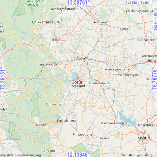
Gorūr GPS coordinates[2]
12° 49' 22.692" North, 76° 3' 52.668" East
| Map corner | latitude | longitude |
|---|---|---|
| Upper-left | 13.50761°, | 75.36151° |
| Center: | 12.82297°, | 76.06463° |
| Lower-right: | 12.13646°, | 76.76776° |
| Map W x H: | 152.5×152.5 km | = 94.8×94.8mi |
| max Lat: | 34.9274° ⇑87.3% North |
| Gorūr: | 12.82297° |
| min Lat: | ⇓12.7% South 8.09008° |
| min Long | Gorūr | max Long |
| 68.82655° | 76.06463° | 96.81° |
| W 27%⇐ | ⇒73% E |
Elevation
Elevation of Gorūr is 878 m = 2881 ft, and this is 582.4 m = 1911 ft above average elevation for this country.
| Max E: |
3681 m = 12077 ft | 5.1% |
| Gorūr | 878 m 2881 ft | |
| Avg. | 295.6 m = 970 ft | |
Min E: |
1 m = 3 ft | 94.9% |
See also: India elevation on elevation.city.
Geographical zone
Gorūr is located in North Torrid zone (between Equator and Tropic of Cancer). Distance of this Northern Tropic circle is 1180.1 km =733.3 mi to North.| Distance of | km | miles | from Gorūr |
|---|---|---|---|
| North Pole | 8581.3 | 5332.2 | to North |
| Arctic Circle | 5975.4 | 3712.9 | to North |
| Tropic Cancer | 1180.1 | 733.3 | to North |
| Equator | 1425.8 | 886 | to South |


Nearby cities:
15 places around Gorūr: (largest is in red/bold)
• Alūr
19 km =11.8 mi,  335°
335°
• Arkalgūd
6.8 km =4.2 mi,  183°
183°
• Belūr
43.8 km =27.2 mi,  330°
330°
• Channarāyapatna
36.2 km =22.5 mi,  75°
75°
• Hassan
20.8 km =12.9 mi,  9°
9°
• Hole Narsipur
19.8 km =12.3 mi,  101°
101°
• Kodlipet
19.5 km =12.1 mi,  262°
262°
• Konanūr
21.5 km =13.4 mi, 184°
• Krishnarājpet
49.1 km =30.5 mi,  110°
110°
• Kushālnagar
42.2 km =26.2 mi,  195°
195°
• Sakleshpur
33.1 km =20.6 mi,  293°
293°
• Sanivārsante
22 km =13.7 mi,  241°
241°
• Somvārpet
34.3 km =21.3 mi,  222°
222°
• Srāvana Belgola
46.1 km =28.6 mi,  85°
85°
• Suntikoppa
48.1 km =29.9 mi,  211°
211°
Sources, notices
• [Note1] Compared only with cities in India existing in our database
• [Src1] Map data: © OpenStreetMap contributors (CC-BY-SA)
• [Src2] Other city data from geonames.org with taken over terms of usage.
• [Src3] Geographical zone / Annual Mean Temperature by Robert A. Rohde @ Wikipedia
